Begamganj geodata
Begamganj (Madhya Pradesh) is a populated place; located in India in Asia/Kolkata (GMT+5.5) time zone. With population of 33,467 people, there are 1299 cities with bigger population in this country. Compared to other cities in India, 55.4% of cities are located further ↓South; 52.6% of cities are located further ←West and 83.3% of cities have lower elevation than Begamganj. Note1


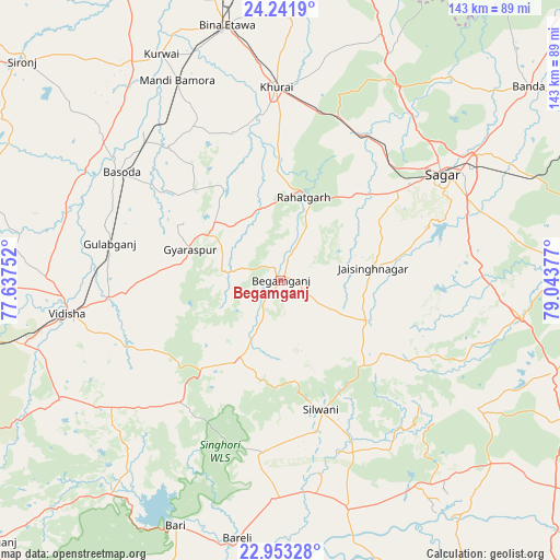
Begamganj GPS coordinates[2]
23° 35' 57.012" North, 78° 20' 26.304" East
| Map corner | latitude | longitude |
|---|---|---|
| Upper-left | 24.2419°, | 77.63752° |
| Center: | 23.59917°, | 78.34064° |
| Lower-right: | 22.95328°, | 79.04377° |
| Map W x H: | 143.3×143.3 km | = 89×89mi |
| max Lat: | 34.9274° ⇑44.6% North |
| Begamganj: | 23.59917° |
| min Lat: | ⇓55.4% South 8.09008° |
| min Long | Begamganj | max Long |
| 68.82655° | 78.34064° | 96.81° |
| W 52.6%⇐ | ⇒47.4% E |
Elevation
Elevation of Begamganj is 513 m = 1683 ft, and this is 217.4 m = 713 ft above average elevation for this country.
| Max E: |
3681 m = 12077 ft | 16.7% |
| Begamganj | 513 m 1683 ft | |
| Avg. | 295.6 m = 970 ft | |
Min E: |
1 m = 3 ft | 83.3% |
See also: India elevation on elevation.city.
Geographical zone
Begamganj is located in North temperate zone (between Tropic of Cancer and the Arctic Circle). Distance of this Northern Tropic circle is 18.1 km =11.2 mi to South.| Distance of | km | miles | from Begamganj |
|---|---|---|---|
| North Pole | 7383.1 | 4587.6 | to North |
| Arctic Circle | 4777.2 | 2968.4 | to North |
| Tropic Cancer | 18.1 | 11.2 | to South |
| Equator | 2624 | 1630.5 | to South |


Nearby cities:
15 places around Begamganj: (largest is in red/bold)
• Bamora
56.8 km =35.3 mi,  333°
333°
• Bāsoda
49.8 km =30.9 mi,  304°
304°
• Dhāna
55.6 km =34.5 mi,  72°
72°
• Etāwa
66.5 km =41.3 mi,  347°
347°
• Jaithāri
51.7 km =32.1 mi,  147°
147°
• Karrāpur
66.1 km =41.1 mi,  53°
53°
• Khurai
49.4 km =30.7 mi,  358°
358°
• Korwai
65.3 km =40.6 mi, 332°
• Raisen
64.4 km =40 mi,  242°
242°
• Rāhatgarh
21.9 km =13.6 mi,  14°
14°
• Saugor
48.5 km =30.1 mi,  56°
56°
• Sultānpur
66 km =41 mi,  218°
218°
• Sānchi
62.7 km =39 mi,  258°
258°
• Udaipura
60.9 km =37.8 mi,  163°
163°
• Vidisha
54.6 km =33.9 mi, 261°
Sources, notices
• [Note1] Compared only with cities in India existing in our database
• [Src1] Map data: © OpenStreetMap contributors (CC-BY-SA)
• [Src2] Other city data from geonames.org with taken over terms of usage.
• [Src3] Geographical zone / Annual Mean Temperature by Robert A. Rohde @ Wikipedia
