Bāsoda geodata
Bāsoda (Madhya Pradesh) is a populated place; located in India in Asia/Kolkata (GMT+5.5) time zone. With population of 69,278 people, there are 625 cities with bigger population in this country. Compared to other cities in India, 57.4% of cities are located further ↓South; 51.9% of cities are located further →East and 76.7% of cities have lower elevation than Bāsoda. Note1


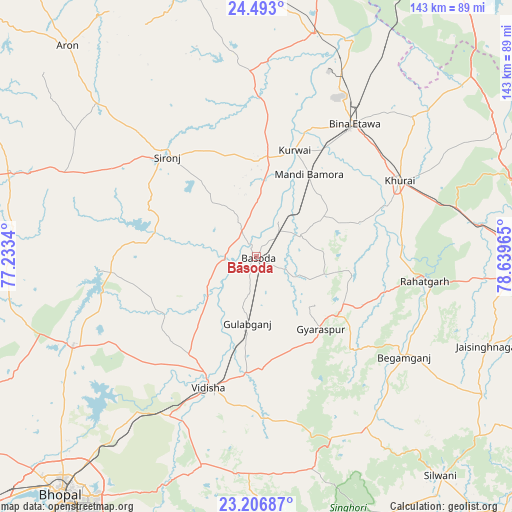
Bāsoda GPS coordinates[2]
23° 51' 5.508" North, 77° 56' 11.472" East
| Map corner | latitude | longitude |
|---|---|---|
| Upper-left | 24.493°, | 77.2334° |
| Center: | 23.85153°, | 77.93652° |
| Lower-right: | 23.20687°, | 78.63965° |
| Map W x H: | 143×143 km | = 88.9×88.9mi |
| max Lat: | 34.9274° ⇑42.6% North |
| Bāsoda: | 23.85153° |
| min Lat: | ⇓57.4% South 8.09008° |
| min Long | Bāsoda | max Long |
| 68.82655° | 77.93652° | 96.81° |
| W 48.1%⇐ | ⇒51.9% E |
Elevation
Elevation of Bāsoda is 410 m = 1345 ft, and this is 114.4 m = 375 ft above average elevation for this country.
| Max E: |
3681 m = 12077 ft | 23.3% |
| Bāsoda | 410 m 1345 ft | |
| Avg. | 295.6 m = 970 ft | |
Min E: |
1 m = 3 ft | 76.7% |
See also: Bāsoda elevation on elevation.city.
Geographical zone
Bāsoda is located in North temperate zone (between Tropic of Cancer and the Arctic Circle). Distance of this Northern Tropic circle is 46.1 km =28.6 mi to South.| Distance of | km | miles | from Bāsoda |
|---|---|---|---|
| North Pole | 7355 | 4570.2 | to North |
| Arctic Circle | 4749.1 | 2951 | to North |
| Tropic Cancer | 46.1 | 28.6 | to South |
| Equator | 2652 | 1647.9 | to South |


Nearby cities:
15 places around Bāsoda: (largest is in red/bold)
• Bamora
27.5 km =17.1 mi,  34°
34°
• Begamganj
49.8 km =30.9 mi,  124°
124°
• Berasia
56.7 km =35.2 mi,  244°
244°
• Etāwa
45.8 km =28.5 mi,  36°
36°
• Garha Brahman
58.9 km =36.6 mi,  271°
271°
• Khurai
45.3 km =28.1 mi,  61°
61°
• Korwai
31.4 km =19.5 mi,  19°
19°
• Leteri
58.4 km =36.3 mi,  293°
293°
• Mungaoli
64 km =39.8 mi,  14°
14°
• Patalpani
59.3 km =36.8 mi, 268°
• Raisen
60.1 km =37.3 mi,  195°
195°
• Rāhatgarh
47.1 km =29.3 mi,  98°
98°
• Sironj
37.5 km =23.3 mi,  318°
318°
• Sānchi
45.4 km =28.2 mi,  206°
206°
• Vidisha
38.4 km =23.9 mi, 199°
Sources, notices
• [Note1] Compared only with cities in India existing in our database
• [Src1] Map data: © OpenStreetMap contributors (CC-BY-SA)
• [Src2] Other city data from geonames.org with taken over terms of usage.
• [Src3] Geographical zone / Annual Mean Temperature by Robert A. Rohde @ Wikipedia
