Saugor geodata
Saugor (Madhya Pradesh) is a populated place; located in India in Asia/Kolkata (GMT+5.5) time zone. With population of 247,333 people, there are 173 cities with bigger population in this country. Compared to other cities in India, 57.2% of cities are located further ↓South; 56.2% of cities are located further ←West and 83.8% of cities have lower elevation than Saugor. Note1


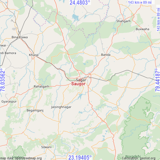
Saugor GPS coordinates[2]
23° 50' 19.572" North, 78° 44' 19.464" East
| Map corner | latitude | longitude |
|---|---|---|
| Upper-left | 24.4803°, | 78.03562° |
| Center: | 23.83877°, | 78.73874° |
| Lower-right: | 23.19405°, | 79.44187° |
| Map W x H: | 143×143 km | = 88.9×88.9mi |
| max Lat: | 34.9274° ⇑42.8% North |
| Saugor: | 23.83877° |
| min Lat: | ⇓57.2% South 8.09008° |
| min Long | Saugor | max Long |
| 68.82655° | 78.73874° | 96.81° |
| W 56.2%⇐ | ⇒43.8% E |
Elevation
Elevation of Saugor is 520 m = 1706 ft, and this is 224.4 m = 736 ft above average elevation for this country.
| Max E: |
3681 m = 12077 ft | 16.2% |
| Saugor | 520 m 1706 ft | |
| Avg. | 295.6 m = 970 ft | |
Min E: |
1 m = 3 ft | 83.8% |
See also: Saugor elevation on elevation.city.
Geographical zone
Saugor is located in North temperate zone (between Tropic of Cancer and the Arctic Circle). Distance of this Northern Tropic circle is 44.7 km =27.8 mi to South.| Distance of | km | miles | from Saugor |
|---|---|---|---|
| North Pole | 7356.4 | 4571.1 | to North |
| Arctic Circle | 4750.6 | 2951.9 | to North |
| Tropic Cancer | 44.7 | 27.8 | to South |
| Equator | 2650.6 | 1647 | to South |


Nearby cities:
15 places around Saugor: (largest is in red/bold)
• Bamora
70.3 km =43.7 mi,  290°
290°
• Banda
32.2 km =20 mi,  44°
44°
• Begamganj
48.5 km =30.1 mi,  236°
236°
• Deori Khās
57.3 km =35.6 mi,  150°
150°
• Dhāna
16.2 km =10.1 mi,  129°
129°
• Etāwa
66.6 km =41.4 mi,  305°
305°
• Garhākota
41.7 km =25.9 mi,  99°
99°
• Jaithāri
71.2 km =44.2 mi,  190°
190°
• Karrāpur
17.8 km =11.1 mi,  46°
46°
• Khurai
47.4 km =29.5 mi,  298°
298°
• Patharia
46.8 km =29.1 mi,  81°
81°
• Rehli
39.9 km =24.8 mi,  124°
124°
• Rāhatgarh
35.4 km =22 mi,  261°
261°
• Shāhgarh
65.4 km =40.6 mi, 36°
• Shāhpur
32.3 km =20.1 mi, 79°
Sources, notices
• [Note1] Compared only with cities in India existing in our database
• [Src1] Map data: © OpenStreetMap contributors (CC-BY-SA)
• [Src2] Other city data from geonames.org with taken over terms of usage.
• [Src3] Geographical zone / Annual Mean Temperature by Robert A. Rohde @ Wikipedia
