Banda geodata
Banda (Madhya Pradesh) is a populated place; located in India in Asia/Kolkata (GMT+5.5) time zone. With population of 28,978 people, there are 1497 cities with bigger population in this country. Compared to other cities in India, 58.4% of cities are located further ↓South; 58.8% of cities are located further ←West and 81.3% of cities have lower elevation than Banda. Note1


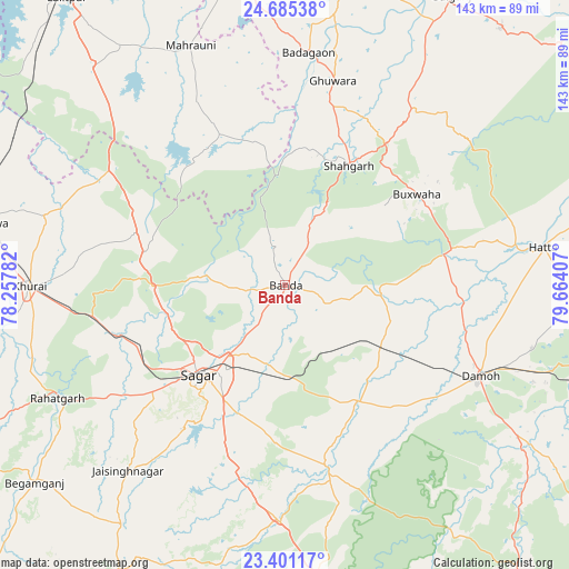
Banda GPS coordinates[2]
24° 2' 41.568" North, 78° 57' 39.384" East
| Map corner | latitude | longitude |
|---|---|---|
| Upper-left | 24.68538°, | 78.25782° |
| Center: | 24.04488°, | 78.96094° |
| Lower-right: | 23.40117°, | 79.66407° |
| Map W x H: | 142.8×142.8 km | = 88.7×88.7mi |
| max Lat: | 34.9274° ⇑41.6% North |
| Banda: | 24.04488° |
| min Lat: | ⇓58.4% South 8.09008° |
| min Long | Banda | max Long |
| 68.82655° | 78.96094° | 96.81° |
| W 58.8%⇐ | ⇒41.2% E |
Elevation
Elevation of Banda is 475 m = 1558 ft, and this is 179.4 m = 589 ft above average elevation for this country.
| Max E: |
3681 m = 12077 ft | 18.7% |
| Banda | 475 m 1558 ft | |
| Avg. | 295.6 m = 970 ft | |
Min E: |
1 m = 3 ft | 81.3% |
See also: India elevation on elevation.city.
Geographical zone
Banda is located in North temperate zone (between Tropic of Cancer and the Arctic Circle). Distance of this Northern Tropic circle is 67.6 km =42 mi to South.| Distance of | km | miles | from Banda |
|---|---|---|---|
| North Pole | 7333.5 | 4556.8 | to North |
| Arctic Circle | 4727.6 | 2937.6 | to North |
| Tropic Cancer | 67.6 | 42 | to South |
| Equator | 2673.5 | 1661.2 | to South |


Nearby cities:
15 places around Banda: (largest is in red/bold)
• Bakshwāho
40.2 km =25 mi,  55°
55°
• Damoh
54.3 km =33.7 mi,  115°
115°
• Dhāna
34.6 km =21.5 mi,  196°
196°
• Garhākota
34.9 km =21.7 mi,  147°
147°
• Hatta
65.7 km =40.8 mi,  81°
81°
• Hindoria
63.7 km =39.6 mi,  104°
104°
• Karrāpur
14.4 km =8.9 mi,  222°
222°
• Khurai
64.1 km =39.8 mi,  269°
269°
• Mahroni
64.7 km =40.2 mi,  338°
338°
• Patharia
28.7 km =17.8 mi, 124°
• Rehli
46.5 km =28.9 mi,  167°
167°
• Rāhatgarh
64.2 km =39.9 mi,  243°
243°
• Saugor
32.2 km =20 mi, 224°
• Shāhgarh
33.9 km =21.1 mi,  28°
28°
• Shāhpur
19.1 km =11.9 mi, 151°
Sources, notices
• [Note1] Compared only with cities in India existing in our database
• [Src1] Map data: © OpenStreetMap contributors (CC-BY-SA)
• [Src2] Other city data from geonames.org with taken over terms of usage.
• [Src3] Geographical zone / Annual Mean Temperature by Robert A. Rohde @ Wikipedia
