Karrāpur geodata
Karrāpur (Madhya Pradesh) is a populated place; located in India in Asia/Kolkata (GMT+5.5) time zone. With population of 9,993 people, there are 2949 cities with bigger population in this country. Compared to other cities in India, 58% of cities are located further ↓South; 57.7% of cities are located further ←West and 82.6% of cities have lower elevation than Karrāpur. Note1


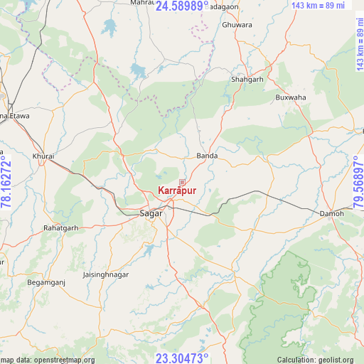
Karrāpur GPS coordinates[2]
23° 56' 56.076" North, 78° 51' 57.024" East
| Map corner | latitude | longitude |
|---|---|---|
| Upper-left | 24.58989°, | 78.16272° |
| Center: | 23.94891°, | 78.86584° |
| Lower-right: | 23.30473°, | 79.56897° |
| Map W x H: | 142.9×142.9 km | = 88.8×88.8mi |
| max Lat: | 34.9274° ⇑42% North |
| Karrāpur: | 23.94891° |
| min Lat: | ⇓58% South 8.09008° |
| min Long | Karrāpur | max Long |
| 68.82655° | 78.86584° | 96.81° |
| W 57.7%⇐ | ⇒42.3% E |
Elevation
Elevation of Karrāpur is 502 m = 1647 ft, and this is 206.4 m = 677 ft above average elevation for this country.
| Max E: |
3681 m = 12077 ft | 17.4% |
| Karrāpur | 502 m 1647 ft | |
| Avg. | 295.6 m = 970 ft | |
Min E: |
1 m = 3 ft | 82.6% |
See also: India elevation on elevation.city.
Geographical zone
Karrāpur is located in North temperate zone (between Tropic of Cancer and the Arctic Circle). Distance of this Northern Tropic circle is 57 km =35.4 mi to South.| Distance of | km | miles | from Karrāpur |
|---|---|---|---|
| North Pole | 7344.2 | 4563.5 | to North |
| Arctic Circle | 4738.3 | 2944.2 | to North |
| Tropic Cancer | 57 | 35.4 | to South |
| Equator | 2662.9 | 1654.6 | to South |


Nearby cities:
15 places around Karrāpur: (largest is in red/bold)
• Bakshwāho
54.3 km =33.7 mi,  51°
51°
• Banda
14.4 km =8.9 mi,  42°
42°
• Begamganj
66.1 km =41.1 mi,  233°
233°
• Damoh
60 km =37.3 mi,  102°
102°
• Deori Khās
64 km =39.8 mi,  166°
166°
• Dhāna
22.5 km =14 mi,  180°
180°
• Garhākota
33.9 km =21.1 mi,  123°
123°
• Hindoria
71.6 km =44.5 mi,  94°
94°
• Khurai
55.4 km =34.4 mi,  280°
280°
• Patharia
33.8 km =21 mi, 99°
• Rehli
40 km =24.9 mi,  149°
149°
• Rāhatgarh
51.1 km =31.8 mi,  249°
249°
• Saugor
17.8 km =11.1 mi, 226°
• Shāhgarh
48 km =29.8 mi,  32°
32°
• Shāhpur
19.8 km =12.3 mi,  108°
108°
Sources, notices
• [Note1] Compared only with cities in India existing in our database
• [Src1] Map data: © OpenStreetMap contributors (CC-BY-SA)
• [Src2] Other city data from geonames.org with taken over terms of usage.
• [Src3] Geographical zone / Annual Mean Temperature by Robert A. Rohde @ Wikipedia
