Mon geodata
Mon (Nagaland) is a populated place; located in India in Asia/Kolkata (GMT+5.5) time zone. With population of 18,742 people, there are 2148 cities with bigger population in this country. Compared to other cities in India, 76.2% of cities are located further ↓South; 99.5% of cities are located further ←West and 96.2% of cities have lower elevation than Mon. Note1


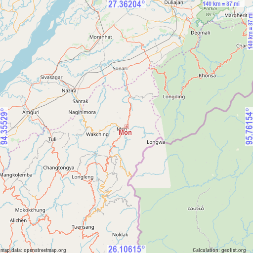
Mon GPS coordinates[2]
26° 44' 8.988" North, 95° 3' 30.276" East
| Map corner | latitude | longitude |
|---|---|---|
| Upper-left | 27.36204°, | 94.35529° |
| Center: | 26.73583°, | 95.05841° |
| Lower-right: | 26.10615°, | 95.76154° |
| Map W x H: | 139.6×139.6 km | = 86.7×86.7mi |
| max Lat: | 34.9274° ⇑23.8% North |
| Mon: | 26.73583° |
| min Lat: | ⇓76.2% South 8.09008° |
| min Long | Mon | max Long |
| 68.82655° | 95.05841° | 96.81° |
| W 99.5%⇐ | ⇒0.5% E |
Elevation
Elevation of Mon is 1000 m = 3281 ft, and this is 704.4 m = 2311 ft above average elevation for this country.
| Max E: |
3681 m = 12077 ft | 3.8% |
| Mon | 1000 m 3281 ft | |
| Avg. | 295.6 m = 970 ft | |
Min E: |
1 m = 3 ft | 96.2% |
See also: India elevation on elevation.city.
Geographical zone
Mon is located in North temperate zone (between Tropic of Cancer and the Arctic Circle). Distance of this Northern Tropic circle is 366.8 km =227.9 mi to South.| Distance of | km | miles | from Mon |
|---|---|---|---|
| North Pole | 7034.3 | 4370.9 | to North |
| Arctic Circle | 4428.4 | 2751.7 | to North |
| Tropic Cancer | 366.8 | 227.9 | to South |
| Equator | 2972.7 | 1847.1 | to South |


Nearby cities:
15 places around Mon: (largest is in red/bold)
• Amguri
53.6 km =33.3 mi,  279°
279°
• Chābua
83.8 km =52.1 mi,  7°
7°
• Duliāgaon
74.9 km =46.5 mi,  19°
19°
• Khonsa
59.3 km =36.8 mi,  58°
58°
• Longleng
36.3 km =22.6 mi,  221°
221°
• Mariāni
74.3 km =46.2 mi,  263°
263°
• Mokokchūng
70.5 km =43.8 mi,  229°
229°
• Morānha
52.2 km =32.4 mi,  344°
344°
• Nahorkatiya
67.6 km =42 mi, 24°
• Nāmrup
57.1 km =35.5 mi,  26°
26°
• Nāzirā
37.8 km =23.5 mi,  302°
302°
• Sibsāgar
50 km =31.1 mi, 303°
• Sonari
37.7 km =23.4 mi,  355°
355°
• Sonāri
32.4 km =20.1 mi,  352°
352°
• Tuensang
57.1 km =35.5 mi,  204°
204°
Sources, notices
• [Note1] Compared only with cities in India existing in our database
• [Src1] Map data: © OpenStreetMap contributors (CC-BY-SA)
• [Src2] Other city data from geonames.org with taken over terms of usage.
• [Src3] Geographical zone / Annual Mean Temperature by Robert A. Rohde @ Wikipedia
