Khedbrahma geodata
Khedbrahma (Gujarat) is a populated place; located in India in Asia/Kolkata (GMT+5.5) time zone. With population of 29,402 people, there are 1475 cities with bigger population in this country. Compared to other cities in India, 58.3% of cities are located further ↓South; 94.5% of cities are located further →East and 51.3% of cities have lower elevation than Khedbrahma. Note1


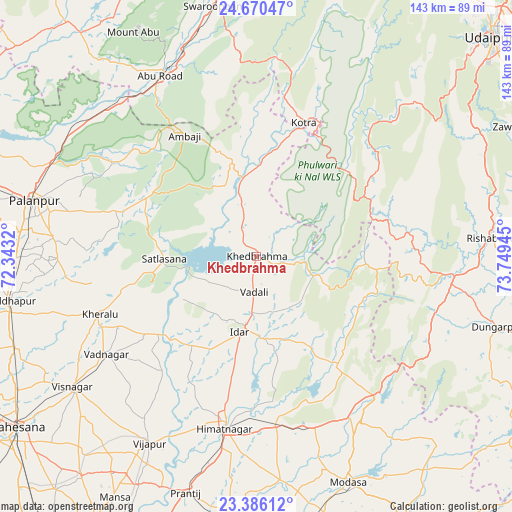
Khedbrahma GPS coordinates[2]
24° 1' 47.64" North, 73° 2' 46.752" East
| Map corner | latitude | longitude |
|---|---|---|
| Upper-left | 24.67047°, | 72.3432° |
| Center: | 24.0299°, | 73.04632° |
| Lower-right: | 23.38612°, | 73.74945° |
| Map W x H: | 142.8×142.8 km | = 88.7×88.7mi |
| max Lat: | 34.9274° ⇑41.7% North |
| Khedbrahma: | 24.0299° |
| min Lat: | ⇓58.3% South 8.09008° |
| min Long | Khedbrahma | max Long |
| 68.82655° | 73.04632° | 96.81° |
| W 5.5%⇐ | ⇒94.5% E |
Elevation
Elevation of Khedbrahma is 209 m = 686 ft, and this is 86.6 m = 284 ft below average elevation for this country.
| Max E: |
3681 m = 12077 ft | 48.7% |
| Avg. | 295.6 m = 970 ft | |
| Khedbrahma | 209 m = 686 ft | |
Min E: |
1 m = 3 ft | 51.3% |
See also: India elevation on elevation.city.
Geographical zone
Khedbrahma is located in North temperate zone (between Tropic of Cancer and the Arctic Circle). Distance of this Northern Tropic circle is 66 km =41 mi to South.| Distance of | km | miles | from Khedbrahma |
|---|---|---|---|
| North Pole | 7335.2 | 4557.9 | to North |
| Arctic Circle | 4729.3 | 2938.6 | to North |
| Tropic Cancer | 66 | 41 | to South |
| Equator | 2671.9 | 1660.2 | to South |


Nearby cities:
15 places around Khedbrahma: (largest is in red/bold)
• Dūngarpur
71 km =44.1 mi,  107°
107°
• Himatnagar
48.6 km =30.2 mi,  189°
189°
• Kherālu
46.3 km =28.8 mi,  249°
249°
• Kānodar
66.6 km =41.4 mi,  275°
275°
• Meghraj
75.9 km =47.2 mi,  141°
141°
• Modāsa
68.1 km =42.3 mi,  157°
157°
• Mānsa
78 km =48.5 mi,  210°
210°
• Pālanpur
63.7 km =39.6 mi, 284°
• Siddhapur
69.6 km =43.2 mi,  259°
259°
• Unjha
71.2 km =44.2 mi, 249°
• Vadnagar
49.5 km =30.8 mi,  236°
236°
• Vijāpur
60.2 km =37.4 mi, 210°
• Visnagar
62.3 km =38.7 mi,  233°
233°
• Ābu
71 km =44.1 mi,  332°
332°
• Ābu Road
56.8 km =35.3 mi, 331°
Sources, notices
• [Note1] Compared only with cities in India existing in our database
• [Src1] Map data: © OpenStreetMap contributors (CC-BY-SA)
• [Src2] Other city data from geonames.org with taken over terms of usage.
• [Src3] Geographical zone / Annual Mean Temperature by Robert A. Rohde @ Wikipedia
