Madhipura geodata
Madhipura (Bihar) is a populated place; located in India in Asia/Kolkata (GMT+5.5) time zone. With population of 50,570 people, there are 879 cities with bigger population in this country. Compared to other cities in India, 69.8% of cities are located further ↓South; 88.9% of cities are located further ←West and 79.4% of cities have higher elevation than Madhipura. Note1


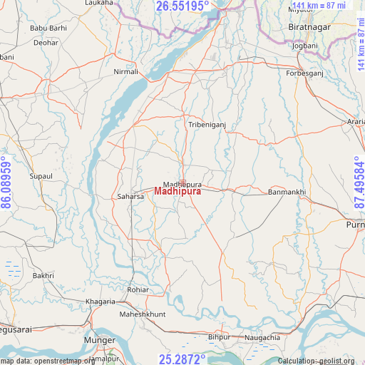
Madhipura GPS coordinates[2]
25° 55' 16.572" North, 86° 47' 33.756" East
| Map corner | latitude | longitude |
|---|---|---|
| Upper-left | 26.55195°, | 86.08959° |
| Center: | 25.92127°, | 86.79271° |
| Lower-right: | 25.2872°, | 87.49584° |
| Map W x H: | 140.6×140.6 km | = 87.4×87.4mi |
| max Lat: | 34.9274° ⇑30.2% North |
| Madhipura: | 25.92127° |
| min Lat: | ⇓69.8% South 8.09008° |
| min Long | Madhipura | max Long |
| 68.82655° | 86.79271° | 96.81° |
| W 88.9%⇐ | ⇒11.1% E |
Elevation
Elevation of Madhipura is 50 m = 164 ft, and this is 245.6 m = 806 ft below average elevation for this country.
| Max E: |
3681 m = 12077 ft | 79.4% |
| Avg. | 295.6 m = 970 ft | |
| Madhipura | 50 m = 164 ft | |
Min E: |
1 m = 3 ft | 20.6% |
See also: Madhipura elevation on elevation.city.
Geographical zone
Madhipura is located in North temperate zone (between Tropic of Cancer and the Arctic Circle). Distance of this Northern Tropic circle is 276.3 km =171.7 mi to South.| Distance of | km | miles | from Madhipura |
|---|---|---|---|
| North Pole | 7124.9 | 4427.2 | to North |
| Arctic Circle | 4519 | 2808 | to North |
| Tropic Cancer | 276.3 | 171.7 | to South |
| Equator | 2882.2 | 1790.9 | to South |


Nearby cities:
15 places around Madhipura: (largest is in red/bold)
• Bangaon
28.8 km =17.9 mi,  257°
257°
• Banmankhi
40.3 km =25 mi,  95°
95°
• Bhawanipur
63.6 km =39.5 mi,  21°
21°
• Bihārīganj
28.6 km =17.8 mi,  136°
136°
• Chhātāpur
39.4 km =24.5 mi,  32°
32°
• Forbesganj
63.4 km =39.4 mi,  48°
48°
• Jhanjhārpur
63.9 km =39.7 mi,  306°
306°
• Khagaria
56.9 km =35.4 mi,  214°
214°
• Monghyr
68.6 km =42.6 mi, 207°
• Murlīganj
20.5 km =12.7 mi, 97°
• Naugachhia
66.8 km =41.5 mi,  152°
152°
• Nirmāli
48.3 km =30 mi,  334°
334°
• Saharsa
20.3 km =12.6 mi, 255°
• Shahbazpur
65.4 km =40.6 mi, 49°
• Supaul
29.2 km =18.1 mi,  317°
317°
Sources, notices
• [Note1] Compared only with cities in India existing in our database
• [Src1] Map data: © OpenStreetMap contributors (CC-BY-SA)
• [Src2] Other city data from geonames.org with taken over terms of usage.
• [Src3] Geographical zone / Annual Mean Temperature by Robert A. Rohde @ Wikipedia
