Ghāziābād geodata
Ghāziābād (Uttar Pradesh) is a seat of a second-order administrative division; located in India in Asia/Kolkata (GMT+5.5) time zone. With population of 1,199,191 people, there are 30 cities with bigger population in this country. Compared to other cities in India, 87.6% of cities are located further ↓South; 57.9% of cities are located further →East and 52.3% of cities have lower elevation than Ghāziābād. Note1


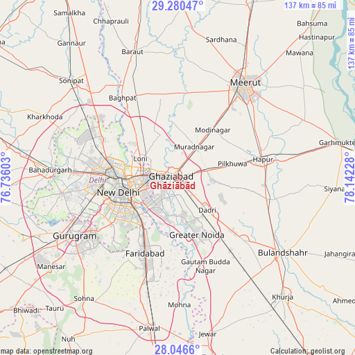
Ghāziābād GPS coordinates[2]
28° 39' 55.26" North, 77° 26' 20.94" East
| Map corner | latitude | longitude |
|---|---|---|
| Upper-left | 29.28047°, | 76.73603° |
| Center: | 28.66535°, | 77.43915° |
| Lower-right: | 28.0466°, | 78.14228° |
| Map W x H: | 137.2×137.2 km | = 85.3×85.3mi |
| max Lat: | 34.9274° ⇑12.4% North |
| Ghāziābād: | 28.66535° |
| min Lat: | ⇓87.6% South 8.09008° |
| min Long | Ghāziābād | max Long |
| 68.82655° | 77.43915° | 96.81° |
| W 42.1%⇐ | ⇒57.9% E |
Elevation
Elevation of Ghāziābād is 214 m = 702 ft, and this is 81.6 m = 268 ft below average elevation for this country.
| Max E: |
3681 m = 12077 ft | 47.7% |
| Avg. | 295.6 m = 970 ft | |
| Ghāziābād | 214 m = 702 ft | |
Min E: |
1 m = 3 ft | 52.3% |
See also: Ghāziābād elevation on elevation.city.
Geographical zone
Ghāziābād is located in North temperate zone (between Tropic of Cancer and the Arctic Circle). Distance of this Northern Tropic circle is 581.4 km =361.3 mi to South.| Distance of | km | miles | from Ghāziābād |
|---|---|---|---|
| North Pole | 6819.8 | 4237.6 | to North |
| Arctic Circle | 4213.9 | 2618.4 | to North |
| Tropic Cancer | 581.4 | 361.3 | to South |
| Equator | 3187.3 | 1980.5 | to South |


Nearby cities:
15 places around Ghāziābād: (largest is in red/bold)
• Defence Colony
22.7 km =14.1 mi,  242°
242°
• Delhi
20.3 km =12.6 mi,  265°
265°
• Dādri
16.8 km =10.4 mi,  138°
138°
• Dāsna
8.2 km =5.1 mi,  80°
80°
• Farīdnagar
21.8 km =13.5 mi,  58°
58°
• Greater Noida
21.1 km =13.1 mi,  153°
153°
• Karol Bāgh
24.3 km =15.1 mi, 266°
• Khekra
26.9 km =16.7 mi,  325°
325°
• Loni
17.4 km =10.8 mi,  303°
303°
• Murādnagar
14.1 km =8.8 mi,  24°
24°
• New Delhi
21.2 km =13.2 mi,  261°
261°
• Niwāri
25.3 km =15.7 mi, 22°
• Noida
14.3 km =8.9 mi,  228°
228°
• Pilkhua
21.8 km =13.5 mi, 76°
• Sector
15.2 km =9.4 mi, 226°
Sources, notices
• [Note1] Compared only with cities in India existing in our database
• [Src1] Map data: © OpenStreetMap contributors (CC-BY-SA)
• [Src2] Other city data from geonames.org with taken over terms of usage.
• [Src3] Geographical zone / Annual Mean Temperature by Robert A. Rohde @ Wikipedia
