Kannauj geodata
Kannauj (Uttar Pradesh) is a populated place; located in India in Asia/Kolkata (GMT+5.5) time zone. With population of 76,714 people, there are 571 cities with bigger population in this country. Compared to other cities in India, 78.9% of cities are located further ↓South; 67.2% of cities are located further ←West and 60.8% of cities have higher elevation than Kannauj. Note1


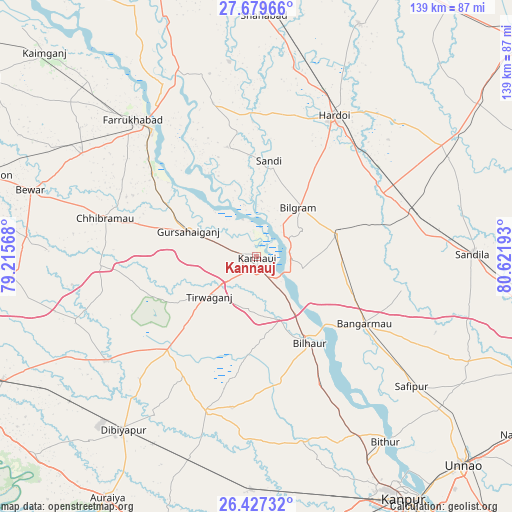
Kannauj GPS coordinates[2]
27° 3' 18.864" North, 79° 55' 7.68" East
| Map corner | latitude | longitude |
|---|---|---|
| Upper-left | 27.67966°, | 79.21568° |
| Center: | 27.05524°, | 79.9188° |
| Lower-right: | 26.42732°, | 80.62193° |
| Map W x H: | 139.2×139.2 km | = 86.5×86.5mi |
| max Lat: | 34.9274° ⇑21.1% North |
| Kannauj: | 27.05524° |
| min Lat: | ⇓78.9% South 8.09008° |
| min Long | Kannauj | max Long |
| 68.82655° | 79.9188° | 96.81° |
| W 67.2%⇐ | ⇒32.8% E |
Elevation
Elevation of Kannauj is 144 m = 472 ft, and this is 151.6 m = 497 ft below average elevation for this country.
| Max E: |
3681 m = 12077 ft | 60.8% |
| Avg. | 295.6 m = 970 ft | |
| Kannauj | 144 m = 472 ft | |
Min E: |
1 m = 3 ft | 39.2% |
See also: Kannauj elevation on elevation.city.
Geographical zone
Kannauj is located in North temperate zone (between Tropic of Cancer and the Arctic Circle). Distance of this Northern Tropic circle is 402.3 km =250 mi to South.| Distance of | km | miles | from Kannauj |
|---|---|---|---|
| North Pole | 6998.8 | 4348.9 | to North |
| Arctic Circle | 4392.9 | 2729.6 | to North |
| Tropic Cancer | 402.3 | 250 | to South |
| Equator | 3008.3 | 1869.3 | to South |


Nearby cities:
15 places around Kannauj: (largest is in red/bold)
• Bilgrām
17.4 km =10.8 mi,  40°
40°
• Bilhaur
27.6 km =17.1 mi,  148°
148°
• Bāngarmau
34.3 km =21.3 mi,  122°
122°
• Chhibrāmau
42.7 km =26.5 mi,  284°
284°
• Fatehgarh
44.6 km =27.7 mi,  320°
320°
• Fatehpur Chaurāsi
45.3 km =28.1 mi,  130°
130°
• Ganj Murādābād
28.4 km =17.6 mi,  112°
112°
• Gursahāiganj
19.7 km =12.2 mi,  289°
289°
• Hardoī
43.2 km =26.8 mi,  29°
29°
• Indergarh
27.9 km =17.3 mi,  241°
241°
• Kamalganj
36.6 km =22.7 mi,  308°
308°
• Mādhoganj
23 km =14.3 mi,  72°
72°
• Saurikh
42.7 km =26.5 mi,  266°
266°
• Sāndi
26.2 km =16.3 mi,  7°
7°
• Tālgrām
26.8 km =16.7 mi, 268°
Sources, notices
• [Note1] Compared only with cities in India existing in our database
• [Src1] Map data: © OpenStreetMap contributors (CC-BY-SA)
• [Src2] Other city data from geonames.org with taken over terms of usage.
• [Src3] Geographical zone / Annual Mean Temperature by Robert A. Rohde @ Wikipedia
