Indergarh geodata
Indergarh (Uttar Pradesh) is a populated place; located in India in Asia/Kolkata (GMT+5.5) time zone. With population of 17,366 people, there are 2249 cities with bigger population in this country. Compared to other cities in India, 78% of cities are located further ↓South; 65.4% of cities are located further ←West and 60.1% of cities have higher elevation than Indergarh. Note1


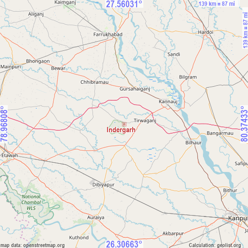
Indergarh GPS coordinates[2]
26° 56' 6.756" North, 79° 40' 16.32" East
| Map corner | latitude | longitude |
|---|---|---|
| Upper-left | 27.56031°, | 78.96808° |
| Center: | 26.93521°, | 79.6712° |
| Lower-right: | 26.30663°, | 80.37433° |
| Map W x H: | 139.4×139.4 km | = 86.6×86.6mi |
| max Lat: | 34.9274° ⇑22% North |
| Indergarh: | 26.93521° |
| min Lat: | ⇓78% South 8.09008° |
| min Long | Indergarh | max Long |
| 68.82655° | 79.6712° | 96.81° |
| W 65.4%⇐ | ⇒34.6% E |
Elevation
Elevation of Indergarh is 148 m = 486 ft, and this is 147.6 m = 484 ft below average elevation for this country.
| Max E: |
3681 m = 12077 ft | 60.1% |
| Avg. | 295.6 m = 970 ft | |
| Indergarh | 148 m = 486 ft | |
Min E: |
1 m = 3 ft | 39.9% |
See also: India elevation on elevation.city.
Geographical zone
Indergarh is located in North temperate zone (between Tropic of Cancer and the Arctic Circle). Distance of this Northern Tropic circle is 389 km =241.7 mi to South.| Distance of | km | miles | from Indergarh |
|---|---|---|---|
| North Pole | 7012.1 | 4357.1 | to North |
| Arctic Circle | 4406.3 | 2737.9 | to North |
| Tropic Cancer | 389 | 241.7 | to South |
| Equator | 2994.9 | 1860.9 | to South |


Nearby cities:
15 places around Indergarh: (largest is in red/bold)
• Bidhūna
21.9 km =13.6 mi,  227°
227°
• Bilgrām
44.6 km =27.7 mi,  53°
53°
• Bilhaur
40.3 km =25 mi,  104°
104°
• Chhibrāmau
29.1 km =18.1 mi,  324°
324°
• Fatehgarh
47.9 km =29.8 mi,  355°
355°
• Gursahāiganj
20.9 km =13 mi,  16°
16°
• Jhīnjhak
42.1 km =26.2 mi,  171°
171°
• Kamalganj
36.5 km =22.7 mi,  353°
353°
• Kannauj
27.9 km =17.3 mi,  61°
61°
• Kishni
41.8 km =26 mi,  283°
283°
• Muhammadābād
47.8 km =29.7 mi,  330°
330°
• Phaphūnd
42.7 km =26.5 mi,  208°
208°
• Saurikh
21 km =13 mi,  300°
300°
• Sāndi
48.1 km =29.9 mi,  35°
35°
• Tālgrām
12.7 km =7.9 mi, 349°
Sources, notices
• [Note1] Compared only with cities in India existing in our database
• [Src1] Map data: © OpenStreetMap contributors (CC-BY-SA)
• [Src2] Other city data from geonames.org with taken over terms of usage.
• [Src3] Geographical zone / Annual Mean Temperature by Robert A. Rohde @ Wikipedia
