Hājipur geodata
Hājipur (Punjab) is a populated place; located in India in Asia/Kolkata (GMT+5.5) time zone. With population of 5,680 people, there are 3310 cities with bigger population in this country. Compared to other cities in India, 97.9% of cities are located further ↓South; 76.2% of cities are located further →East and 67.8% of cities have lower elevation than Hājipur. Note1


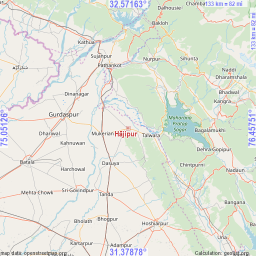
Hājipur GPS coordinates[2]
31° 58' 37.704" North, 75° 45' 15.768" East
| Map corner | latitude | longitude |
|---|---|---|
| Upper-left | 32.57163°, | 75.05126° |
| Center: | 31.97714°, | 75.75438° |
| Lower-right: | 31.37878°, | 76.45751° |
| Map W x H: | 132.6×132.6 km | = 82.4×82.4mi |
| max Lat: | 34.9274° ⇑2.1% North |
| Hājipur: | 31.97714° |
| min Lat: | ⇓97.9% South 8.09008° |
| min Long | Hājipur | max Long |
| 68.82655° | 75.75438° | 96.81° |
| W 23.8%⇐ | ⇒76.2% E |
Elevation
Elevation of Hājipur is 307 m = 1007 ft, and this is 11.4 m = 37 ft above average elevation for this country.
| Max E: |
3681 m = 12077 ft | 32.2% |
| Hājipur | 307 m 1007 ft | |
| Avg. | 295.6 m = 970 ft | |
Min E: |
1 m = 3 ft | 67.8% |
See also: India elevation on elevation.city.
Geographical zone
Hājipur is located in North temperate zone (between Tropic of Cancer and the Arctic Circle). Distance of this Northern Tropic circle is 949.6 km =590.1 mi to South.| Distance of | km | miles | from Hājipur |
|---|---|---|---|
| North Pole | 6451.5 | 4008.8 | to North |
| Arctic Circle | 3845.6 | 2389.5 | to North |
| Tropic Cancer | 949.6 | 590.1 | to South |
| Equator | 3555.5 | 2209.3 | to South |


Nearby cities:
15 places around Hājipur: (largest is in red/bold)
• Begowāl
46.2 km =28.7 mi,  208°
208°
• Dasūya
20.2 km =12.6 mi, 208°
• Daulatpur
30.7 km =19.1 mi,  133°
133°
• Dera Gopipur
45.2 km =28.1 mi,  103°
103°
• Dhāriwāl
40.7 km =25.3 mi,  266°
266°
• Dīnānagar
31.9 km =19.8 mi,  303°
303°
• Gagret
45.8 km =28.5 mi,  140°
140°
• Garhdiwāla
26.2 km =16.3 mi,  179°
179°
• Hariāna
38.9 km =24.2 mi,  168°
168°
• Kotla
40.1 km =24.9 mi,  40°
40°
• Mukeriān
13.2 km =8.2 mi,  258°
258°
• Nagrota
33 km =20.5 mi,  74°
74°
• Pathānkot
34.5 km =21.4 mi,  343°
343°
• Qādiān
39.6 km =24.6 mi,  244°
244°
• Talwāra
13.2 km =8.2 mi,  109°
109°
Sources, notices
• [Note1] Compared only with cities in India existing in our database
• [Src1] Map data: © OpenStreetMap contributors (CC-BY-SA)
• [Src2] Other city data from geonames.org with taken over terms of usage.
• [Src3] Geographical zone / Annual Mean Temperature by Robert A. Rohde @ Wikipedia
