Parol geodata
Parol (Jammu and Kashmir) is a populated place; located in India in Asia/Kolkata (GMT+5.5) time zone. With population of 7,800 people, there are 3138 cities with bigger population in this country. Compared to other cities in India, 98.3% of cities are located further ↓South; 79% of cities are located further →East and 65.2% of cities have lower elevation than Parol. Note1


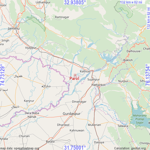
Parol GPS coordinates[2]
32° 20' 45.528" North, 75° 26' 3.876" East
| Map corner | latitude | longitude |
|---|---|---|
| Upper-left | 32.93805°, | 74.73129° |
| Center: | 32.34598°, | 75.43441° |
| Lower-right: | 31.75001°, | 76.13754° |
| Map W x H: | 132.1×132.1 km | = 82.1×82.1mi |
| max Lat: | 34.9274° ⇑1.7% North |
| Parol: | 32.34598° |
| min Lat: | ⇓98.3% South 8.09008° |
| min Long | Parol | max Long |
| 68.82655° | 75.43441° | 96.81° |
| W 21%⇐ | ⇒79% E |
Elevation
Elevation of Parol is 287 m = 942 ft, and this is 8.6 m = 28 ft below average elevation for this country.
| Max E: |
3681 m = 12077 ft | 34.8% |
| Avg. | 295.6 m = 970 ft | |
| Parol | 287 m = 942 ft | |
Min E: |
1 m = 3 ft | 65.2% |
See also: India elevation on elevation.city.
Geographical zone
Parol is located in North temperate zone (between Tropic of Cancer and the Arctic Circle). Distance of this Northern Tropic circle is 990.6 km =615.5 mi to South.| Distance of | km | miles | from Parol |
|---|---|---|---|
| North Pole | 6410.5 | 3983.3 | to North |
| Arctic Circle | 3804.6 | 2364.1 | to North |
| Tropic Cancer | 990.6 | 615.5 | to South |
| Equator | 3596.5 | 2234.8 | to South |


Nearby cities:
15 places around Parol: (largest is in red/bold)
• Bakloh
47.8 km =29.7 mi,  71°
71°
• Chowari
55.1 km =34.2 mi,  80°
80°
• Dalhousie
53.3 km =33.1 mi,  64°
64°
• Derā Nānak
51.4 km =31.9 mi,  228°
228°
• Dhāriwāl
44.6 km =27.7 mi,  193°
193°
• Dīnānagar
23.6 km =14.7 mi,  171°
171°
• Gho Brāhmanān de
50.8 km =31.6 mi,  297°
297°
• Hirānagar
19.5 km =12.1 mi,  308°
308°
• Hājipur
50.9 km =31.6 mi,  143°
143°
• Kalanaur
45.7 km =28.4 mi,  215°
215°
• Kathua
8.9 km =5.5 mi, 73°
• Mukeriān
46.9 km =29.1 mi,  158°
158°
• Pathānkot
22 km =13.7 mi,  111°
111°
• Rāmnagar
52.6 km =32.7 mi,  347°
347°
• Sāmba
38.1 km =23.7 mi, 309°
Sources, notices
• [Note1] Compared only with cities in India existing in our database
• [Src1] Map data: © OpenStreetMap contributors (CC-BY-SA)
• [Src2] Other city data from geonames.org with taken over terms of usage.
• [Src3] Geographical zone / Annual Mean Temperature by Robert A. Rohde @ Wikipedia
