Lansdowne geodata
Lansdowne (Uttarakhand) is a populated place; located in India in Asia/Kolkata (GMT+5.5) time zone. With population of 8,198 people, there are 3110 cities with bigger population in this country. Compared to other cities in India, 92.4% of cities are located further ↓South; 55.8% of cities are located further ←West and 98.8% of cities have lower elevation than Lansdowne. Note1


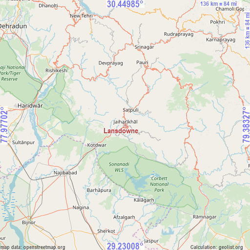
Lansdowne GPS coordinates[2]
29° 50' 30.588" North, 78° 40' 48.504" East
| Map corner | latitude | longitude |
|---|---|---|
| Upper-left | 30.44985°, | 77.97702° |
| Center: | 29.84183°, | 78.68014° |
| Lower-right: | 29.23008°, | 79.38327° |
| Map W x H: | 135.6×135.6 km | = 84.3×84.3mi |
| max Lat: | 34.9274° ⇑7.6% North |
| Lansdowne: | 29.84183° |
| min Lat: | ⇓92.4% South 8.09008° |
| min Long | Lansdowne | max Long |
| 68.82655° | 78.68014° | 96.81° |
| W 55.8%⇐ | ⇒44.2% E |
Elevation
Elevation of Lansdowne is 1701 m = 5581 ft, and this is 1405.4 m = 4611 ft above average elevation for this country.
| Max E: |
3681 m = 12077 ft | 1.2% |
| Lansdowne | 1701 m 5581 ft | |
| Avg. | 295.6 m = 970 ft | |
Min E: |
1 m = 3 ft | 98.8% |
See also: India elevation on elevation.city.
Geographical zone
Lansdowne is located in North temperate zone (between Tropic of Cancer and the Arctic Circle). Distance of this Northern Tropic circle is 712.2 km =442.5 mi to South.| Distance of | km | miles | from Lansdowne |
|---|---|---|---|
| North Pole | 6689 | 4156.4 | to North |
| Arctic Circle | 4083.1 | 2537.1 | to North |
| Tropic Cancer | 712.2 | 442.5 | to South |
| Equator | 3318.1 | 2061.8 | to South |


Nearby cities:
15 places around Lansdowne: (largest is in red/bold)
• Afzalgarh
49.8 km =30.9 mi,  180°
180°
• Birbhaddar
46.1 km =28.6 mi,  303°
303°
• Devaprayāg
34.6 km =21.5 mi,  347°
347°
• Dugadda
7.7 km =4.8 mi,  239°
239°
• Haridwar
51.5 km =32 mi,  283°
283°
• Kotdwāra
18.6 km =11.6 mi, 235°
• Kālāgarh Project Colony
41.7 km =25.9 mi,  166°
166°
• Nagīna
50.1 km =31.1 mi,  208°
208°
• Najībābād
41.4 km =25.7 mi,  231°
231°
• Narendranagar
51.9 km =32.2 mi,  313°
313°
• Pauri
35.8 km =22.2 mi,  15°
15°
• Rishīkesh
47.6 km =29.6 mi, 308°
• Rāīwāla Bara
47.7 km =29.6 mi,  294°
294°
• Srīnagar
43.5 km =27 mi,  13°
13°
• Sultānpur
55.8 km =34.7 mi,  260°
260°
Sources, notices
• [Note1] Compared only with cities in India existing in our database
• [Src1] Map data: © OpenStreetMap contributors (CC-BY-SA)
• [Src2] Other city data from geonames.org with taken over terms of usage.
• [Src3] Geographical zone / Annual Mean Temperature by Robert A. Rohde @ Wikipedia
