Robertsonpet geodata
Robertsonpet (Karnataka) is a populated place; located in India in Asia/Kolkata (GMT+5.5) time zone. With population of 135,218 people, there are 320 cities with bigger population in this country. Compared to other cities in India, 86.7% of cities are located further ↑North; 52.1% of cities are located further ←West and 94.6% of cities have lower elevation than Robertsonpet. Note1


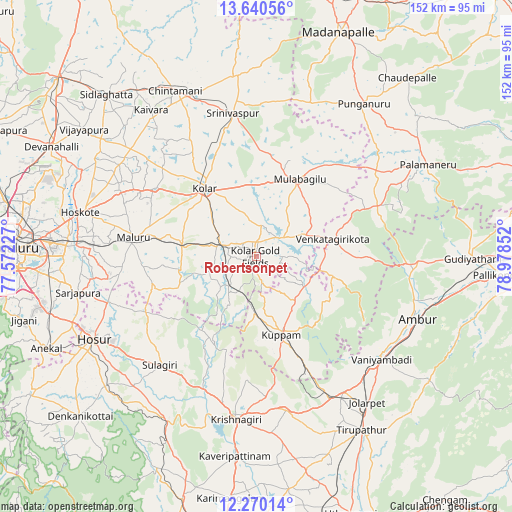
Robertsonpet GPS coordinates[2]
12° 57' 22.644" North, 78° 16' 31.404" East
| Map corner | latitude | longitude |
|---|---|---|
| Upper-left | 13.64056°, | 77.57227° |
| Center: | 12.95629°, | 78.27539° |
| Lower-right: | 12.27014°, | 78.97852° |
| Map W x H: | 152.4×152.4 km | = 94.7×94.7mi |
| max Lat: | 34.9274° ⇑86.7% North |
| Robertsonpet: | 12.95629° |
| min Lat: | ⇓13.3% South 8.09008° |
| min Long | Robertsonpet | max Long |
| 68.82655° | 78.27539° | 96.81° |
| W 52.1%⇐ | ⇒47.9% E |
Elevation
Elevation of Robertsonpet is 851 m = 2792 ft, and this is 555.4 m = 1822 ft above average elevation for this country.
| Max E: |
3681 m = 12077 ft | 5.4% |
| Robertsonpet | 851 m 2792 ft | |
| Avg. | 295.6 m = 970 ft | |
Min E: |
1 m = 3 ft | 94.6% |
See also: Robertsonpet elevation on elevation.city.
Geographical zone
Robertsonpet is located in North Torrid zone (between Equator and Tropic of Cancer). Distance of this Northern Tropic circle is 1165.3 km =724.1 mi to North.| Distance of | km | miles | from Robertsonpet |
|---|---|---|---|
| North Pole | 8566.5 | 5323 | to North |
| Arctic Circle | 5960.6 | 3703.7 | to North |
| Tropic Cancer | 1165.3 | 724.1 | to North |
| Equator | 1440.6 | 895.1 | to South |


Nearby cities:
15 places around Robertsonpet: (largest is in red/bold)
• Ambur
51.2 km =31.8 mi,  110°
110°
• Bangarapet
11.2 km =7 mi,  290°
290°
• Chintāmani
55 km =34.2 mi,  333°
333°
• Dasarahalli
50.6 km =31.4 mi, 288°
• Hoskote
53.2 km =33.1 mi,  283°
283°
• Hosūr
53.9 km =33.5 mi,  243°
243°
• Jalārpet
53.7 km =33.4 mi,  143°
143°
• Kolār
25.6 km =15.9 mi,  322°
322°
• Krishnagiri
49.1 km =30.5 mi,  187°
187°
• Kuppam
24.1 km =15 mi,  162°
162°
• Mulbāgal
26.4 km =16.4 mi,  29°
29°
• Mālūr
36.9 km =22.9 mi, 278°
• Peranāmpattu
48.1 km =29.9 mi,  92°
92°
• Srīnivāspur
43.1 km =26.8 mi,  350°
350°
• Vaniyambadi
48.3 km =30 mi,  129°
129°
Sources, notices
• [Note1] Compared only with cities in India existing in our database
• [Src1] Map data: © OpenStreetMap contributors (CC-BY-SA)
• [Src2] Other city data from geonames.org with taken over terms of usage.
• [Src3] Geographical zone / Annual Mean Temperature by Robert A. Rohde @ Wikipedia
