Jharsuguda geodata
Jharsuguda (Odisha) is a seat of a second-order administrative division; located in India in Asia/Kolkata (GMT+5.5) time zone. With population of 79,492 people, there are 549 cities with bigger population in this country. Compared to other cities in India, 57.2% of cities are located further ↑North; 82% of cities are located further ←West and 53.3% of cities have lower elevation than Jharsuguda. Note1


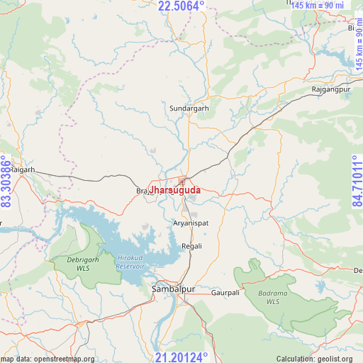
Jharsuguda GPS coordinates[2]
21° 51' 19.116" North, 84° 0' 25.128" East
| Map corner | latitude | longitude |
|---|---|---|
| Upper-left | 22.5064°, | 83.30386° |
| Center: | 21.85531°, | 84.00698° |
| Lower-right: | 21.20124°, | 84.71011° |
| Map W x H: | 145.1×145.1 km | = 90.2×90.2mi |
| max Lat: | 34.9274° ⇑57.2% North |
| Jharsuguda: | 21.85531° |
| min Lat: | ⇓42.8% South 8.09008° |
| min Long | Jharsuguda | max Long |
| 68.82655° | 84.00698° | 96.81° |
| W 82%⇐ | ⇒18% E |
Elevation
Elevation of Jharsuguda is 219 m = 719 ft, and this is 76.6 m = 251 ft below average elevation for this country.
| Max E: |
3681 m = 12077 ft | 46.7% |
| Avg. | 295.6 m = 970 ft | |
| Jharsuguda | 219 m = 719 ft | |
Min E: |
1 m = 3 ft | 53.3% |
See also: Jharsuguda elevation on elevation.city.
Geographical zone
Jharsuguda is located in North Torrid zone (between Equator and Tropic of Cancer). Distance of this Northern Tropic circle is 175.8 km =109.2 mi to North.| Distance of | km | miles | from Jharsuguda |
|---|---|---|---|
| North Pole | 7577 | 4708.1 | to North |
| Arctic Circle | 4971.1 | 3088.9 | to North |
| Tropic Cancer | 175.8 | 109.2 | to North |
| Equator | 2430.1 | 1510 | to South |


Nearby cities:
15 places around Jharsuguda: (largest is in red/bold)
• Bargarh
70.5 km =43.8 mi,  214°
214°
• Barpāli
85.8 km =53.3 mi, 210°
• Binka
94.4 km =58.7 mi,  192°
192°
• Brājarājnagar
10.3 km =6.4 mi,  245°
245°
• Burla
40.9 km =25.4 mi,  199°
199°
• Bānposh
93.6 km =58.2 mi,  62°
62°
• Deogarh
82.9 km =51.5 mi,  115°
115°
• Gharghoda
76.3 km =47.4 mi,  297°
297°
• Hīrākud
39.3 km =24.4 mi, 200°
• Kharsia
94.3 km =58.6 mi,  279°
279°
• Kuchinda
37.4 km =23.2 mi,  109°
109°
• Raigarh
63.2 km =39.3 mi,  274°
274°
• Rengāli
23.8 km =14.8 mi,  168°
168°
• Sambalpur
43.5 km =27 mi,  184°
184°
• Sundargarh
29.2 km =18.1 mi,  5°
5°
Sources, notices
• [Note1] Compared only with cities in India existing in our database
• [Src1] Map data: © OpenStreetMap contributors (CC-BY-SA)
• [Src2] Other city data from geonames.org with taken over terms of usage.
• [Src3] Geographical zone / Annual Mean Temperature by Robert A. Rohde @ Wikipedia
