Sundargarh geodata
Sundargarh (Odisha) is a populated place; located in India in Asia/Kolkata (GMT+5.5) time zone. With population of 41,705 people, there are 1060 cities with bigger population in this country. Compared to other cities in India, 55.9% of cities are located further ↑North; 82% of cities are located further ←West and 58% of cities have lower elevation than Sundargarh. Note1


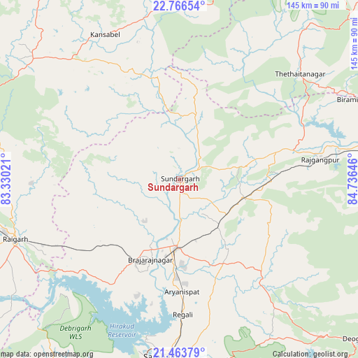
Sundargarh GPS coordinates[2]
22° 7' 0.012" North, 84° 1' 59.988" East
| Map corner | latitude | longitude |
|---|---|---|
| Upper-left | 22.76654°, | 83.33021° |
| Center: | 22.11667°, | 84.03333° |
| Lower-right: | 21.46379°, | 84.73646° |
| Map W x H: | 144.9×144.9 km | = 90×90mi |
| max Lat: | 34.9274° ⇑55.9% North |
| Sundargarh: | 22.11667° |
| min Lat: | ⇓44.1% South 8.09008° |
| min Long | Sundargarh | max Long |
| 68.82655° | 84.03333° | 96.81° |
| W 82%⇐ | ⇒18% E |
Elevation
Elevation of Sundargarh is 239 m = 784 ft, and this is 56.6 m = 186 ft below average elevation for this country.
| Max E: |
3681 m = 12077 ft | 42% |
| Avg. | 295.6 m = 970 ft | |
| Sundargarh | 239 m = 784 ft | |
Min E: |
1 m = 3 ft | 58% |
See also: Sundargarh elevation on elevation.city.
Geographical zone
Sundargarh is located in North Torrid zone (between Equator and Tropic of Cancer). Distance of this Northern Tropic circle is 146.8 km =91.2 mi to North.| Distance of | km | miles | from Sundargarh |
|---|---|---|---|
| North Pole | 7547.9 | 4690 | to North |
| Arctic Circle | 4942 | 3070.8 | to North |
| Tropic Cancer | 146.8 | 91.2 | to North |
| Equator | 2459.1 | 1528 | to South |


Nearby cities:
15 places around Sundargarh: (largest is in red/bold)
• Birmitrapur
81.8 km =50.8 mi,  67°
67°
• Brājarājnagar
35.5 km =22.1 mi,  199°
199°
• Burla
69.5 km =43.2 mi,  193°
193°
• Bānposh
81.3 km =50.5 mi,  79°
79°
• Gharghoda
70.5 km =43.8 mi,  275°
275°
• Hīrākud
67.8 km =42.1 mi, 194°
• Jashpurnagar
86.4 km =53.7 mi,  7°
7°
• Jharsuguda
29.2 km =18.1 mi, 185°
• Kuchinda
52.7 km =32.7 mi,  141°
141°
• Pathalgaon
76.3 km =47.4 mi,  309°
309°
• Raigarh
70 km =43.5 mi,  249°
249°
• Raurkela
86.4 km =53.7 mi, 81°
• Rengāli
52.4 km =32.6 mi,  177°
177°
• Sambalpur
72.7 km =45.2 mi, 184°
• Simdega
73.5 km =45.7 mi,  41°
41°
Sources, notices
• [Note1] Compared only with cities in India existing in our database
• [Src1] Map data: © OpenStreetMap contributors (CC-BY-SA)
• [Src2] Other city data from geonames.org with taken over terms of usage.
• [Src3] Geographical zone / Annual Mean Temperature by Robert A. Rohde @ Wikipedia
