Rengāli geodata
Rengāli (Odisha) is a populated place; located in India in Asia/Kolkata (GMT+5.5) time zone. With population of 7,701 people, there are 3149 cities with bigger population in this country. Compared to other cities in India, 58.3% of cities are located further ↑North; 82.1% of cities are located further ←West and 52.6% of cities have lower elevation than Rengāli. Note1


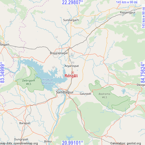
Rengāli GPS coordinates[2]
21° 38' 45.672" North, 84° 3' 11.196" East
| Map corner | latitude | longitude |
|---|---|---|
| Upper-left | 22.29807°, | 83.34999° |
| Center: | 21.64602°, | 84.05311° |
| Lower-right: | 20.99101°, | 84.75624° |
| Map W x H: | 145.3×145.3 km | = 90.3×90.3mi |
| max Lat: | 34.9274° ⇑58.3% North |
| Rengāli: | 21.64602° |
| min Lat: | ⇓41.7% South 8.09008° |
| min Long | Rengāli | max Long |
| 68.82655° | 84.05311° | 96.81° |
| W 82.1%⇐ | ⇒17.9% E |
Elevation
Elevation of Rengāli is 216 m = 709 ft, and this is 79.6 m = 261 ft below average elevation for this country.
| Max E: |
3681 m = 12077 ft | 47.4% |
| Avg. | 295.6 m = 970 ft | |
| Rengāli | 216 m = 709 ft | |
Min E: |
1 m = 3 ft | 52.6% |
See also: India elevation on elevation.city.
Geographical zone
Rengāli is located in North Torrid zone (between Equator and Tropic of Cancer). Distance of this Northern Tropic circle is 199.1 km =123.7 mi to North.| Distance of | km | miles | from Rengāli |
|---|---|---|---|
| North Pole | 7600.3 | 4722.6 | to North |
| Arctic Circle | 4994.4 | 3103.4 | to North |
| Tropic Cancer | 199.1 | 123.7 | to North |
| Equator | 2406.8 | 1495.5 | to South |


Nearby cities:
15 places around Rengāli: (largest is in red/bold)
• Bargarh
56.8 km =35.3 mi,  232°
232°
• Barpāli
70 km =43.5 mi,  223°
223°
• Baud
94.2 km =58.5 mi,  162°
162°
• Binka
73.3 km =45.5 mi,  199°
199°
• Brājarājnagar
23.6 km =14.7 mi,  323°
323°
• Burla
24 km =14.9 mi, 230°
• Deogarh
71.3 km =44.3 mi,  99°
99°
• Gharghoda
93.2 km =57.9 mi,  309°
309°
• Hīrākud
23 km =14.3 mi, 234°
• Jharsuguda
23.8 km =14.8 mi,  348°
348°
• Kuchinda
32.4 km =20.1 mi,  70°
70°
• Raigarh
73.3 km =45.5 mi,  292°
292°
• Sambalpur
21.6 km =13.4 mi, 201°
• Sonepur
91.5 km =56.9 mi,  188°
188°
• Sundargarh
52.4 km =32.6 mi,  357°
357°
Sources, notices
• [Note1] Compared only with cities in India existing in our database
• [Src1] Map data: © OpenStreetMap contributors (CC-BY-SA)
• [Src2] Other city data from geonames.org with taken over terms of usage.
• [Src3] Geographical zone / Annual Mean Temperature by Robert A. Rohde @ Wikipedia
