Gharghoda geodata
Gharghoda (Chhattisgarh) is a populated place; located in India in Asia/Kolkata (GMT+5.5) time zone. With population of 8,512 people, there are 3080 cities with bigger population in this country. Compared to other cities in India, 55.6% of cities are located further ↑North; 80.4% of cities are located further ←West and 66% of cities have lower elevation than Gharghoda. Note1


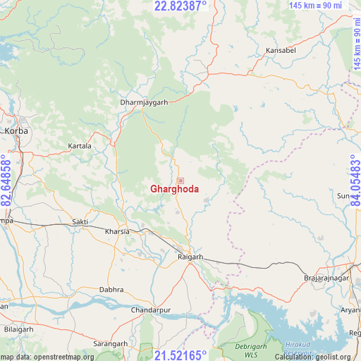
Gharghoda GPS coordinates[2]
22° 10' 27.372" North, 83° 21' 6.12" East
| Map corner | latitude | longitude |
|---|---|---|
| Upper-left | 22.82387°, | 82.64858° |
| Center: | 22.17427°, | 83.3517° |
| Lower-right: | 21.52165°, | 84.05483° |
| Map W x H: | 144.8×144.8 km | = 90×90mi |
| max Lat: | 34.9274° ⇑55.6% North |
| Gharghoda: | 22.17427° |
| min Lat: | ⇓44.4% South 8.09008° |
| min Long | Gharghoda | max Long |
| 68.82655° | 83.3517° | 96.81° |
| W 80.4%⇐ | ⇒19.6% E |
Elevation
Elevation of Gharghoda is 294 m = 965 ft, and this is 1.6 m = 5 ft below average elevation for this country.
| Max E: |
3681 m = 12077 ft | 34% |
| Avg. | 295.6 m = 970 ft | |
| Gharghoda | 294 m = 965 ft | |
Min E: |
1 m = 3 ft | 66% |
See also: India elevation on elevation.city.
Geographical zone
Gharghoda is located in North Torrid zone (between Equator and Tropic of Cancer). Distance of this Northern Tropic circle is 140.4 km =87.2 mi to North.| Distance of | km | miles | from Gharghoda |
|---|---|---|---|
| North Pole | 7541.5 | 4686.1 | to North |
| Arctic Circle | 4935.6 | 3066.8 | to North |
| Tropic Cancer | 140.4 | 87.2 | to North |
| Equator | 2465.5 | 1532 | to South |


Nearby cities:
15 places around Gharghoda: (largest is in red/bold)
• Baloda
89.7 km =55.7 mi,  267°
267°
• Brājarājnagar
70.5 km =43.8 mi,  124°
124°
• Burla
91.4 km =56.8 mi,  143°
143°
• Chāmpa
74.7 km =46.4 mi,  258°
258°
• Hīrākud
90 km =55.9 mi, 143°
• Jharsuguda
76.3 km =47.4 mi, 117°
• Jānjgīr
81.8 km =50.8 mi, 257°
• Katghora
90.8 km =56.4 mi,  293°
293°
• Kharsia
32.7 km =20.3 mi,  231°
231°
• Korba
70.1 km =43.6 mi, 285°
• Pathalgaon
44 km =27.3 mi,  15°
15°
• Raigarh
31.1 km =19.3 mi,  171°
171°
• Saktī
43.5 km =27 mi,  247°
247°
• Sundargarh
70.5 km =43.8 mi,  95°
95°
• Sārangarh
71.2 km =44.2 mi,  203°
203°
Sources, notices
• [Note1] Compared only with cities in India existing in our database
• [Src1] Map data: © OpenStreetMap contributors (CC-BY-SA)
• [Src2] Other city data from geonames.org with taken over terms of usage.
• [Src3] Geographical zone / Annual Mean Temperature by Robert A. Rohde @ Wikipedia
