Bargarh geodata
Bargarh (Odisha) is a populated place; located in India in Asia/Kolkata (GMT+5.5) time zone. With population of 68,670 people, there are 628 cities with bigger population in this country. Compared to other cities in India, 59.9% of cities are located further ↑North; 81.1% of cities are located further ←West and 54.3% of cities have higher elevation than Bargarh. Note1


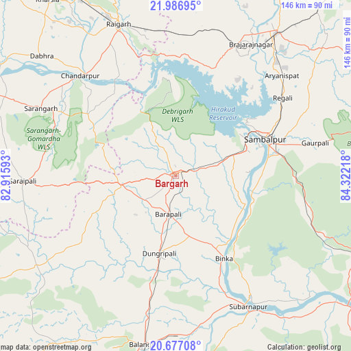
Bargarh GPS coordinates[2]
21° 20' 0.528" North, 83° 37' 8.58" East
| Map corner | latitude | longitude |
|---|---|---|
| Upper-left | 21.98695°, | 82.91593° |
| Center: | 21.33348°, | 83.61905° |
| Lower-right: | 20.67708°, | 84.32218° |
| Map W x H: | 145.6×145.6 km | = 90.5×90.5mi |
| max Lat: | 34.9274° ⇑59.9% North |
| Bargarh: | 21.33348° |
| min Lat: | ⇓40.1% South 8.09008° |
| min Long | Bargarh | max Long |
| 68.82655° | 83.61905° | 96.81° |
| W 81.1%⇐ | ⇒18.9% E |
Elevation
Elevation of Bargarh is 179 m = 587 ft, and this is 116.6 m = 383 ft below average elevation for this country.
| Max E: |
3681 m = 12077 ft | 54.3% |
| Avg. | 295.6 m = 970 ft | |
| Bargarh | 179 m = 587 ft | |
Min E: |
1 m = 3 ft | 45.7% |
See also: Bargarh elevation on elevation.city.
Geographical zone
Bargarh is located in North Torrid zone (between Equator and Tropic of Cancer). Distance of this Northern Tropic circle is 233.9 km =145.3 mi to North.| Distance of | km | miles | from Bargarh |
|---|---|---|---|
| North Pole | 7635 | 4744.2 | to North |
| Arctic Circle | 5029.1 | 3124.9 | to North |
| Tropic Cancer | 233.9 | 145.3 | to North |
| Equator | 2372.1 | 1474 | to South |


Nearby cities:
15 places around Bargarh: (largest is in red/bold)
• Balāngīr
71.2 km =44.2 mi,  190°
190°
• Barpāli
16.3 km =10.1 mi, 191°
• Binka
39.6 km =24.6 mi,  149°
149°
• Brājarājnagar
61.9 km =38.5 mi,  29°
29°
• Burla
32.8 km =20.4 mi,  53°
53°
• Hīrākud
33.8 km =21 mi, 50°
• Jharsuguda
70.5 km =43.8 mi, 34°
• Padampur
68.6 km =42.6 mi,  237°
237°
• Raigarh
66.8 km =41.5 mi,  339°
339°
• Rengāli
56.8 km =35.3 mi, 52°
• Sambalpur
39.7 km =24.7 mi,  68°
68°
• Saraipali
63.5 km =39.5 mi,  268°
268°
• Sonepur
63.6 km =39.5 mi, 150°
• Sārangarh
62.6 km =38.9 mi,  296°
296°
• Tarabha
67.1 km =41.7 mi,  175°
175°
Sources, notices
• [Note1] Compared only with cities in India existing in our database
• [Src1] Map data: © OpenStreetMap contributors (CC-BY-SA)
• [Src2] Other city data from geonames.org with taken over terms of usage.
• [Src3] Geographical zone / Annual Mean Temperature by Robert A. Rohde @ Wikipedia
