Binka geodata
Binka (Odisha) is a populated place; located in India in Asia/Kolkata (GMT+5.5) time zone. With population of 15,095 people, there are 2451 cities with bigger population in this country. Compared to other cities in India, 61.6% of cities are located further ↑North; 81.5% of cities are located further ←West and 64.2% of cities have higher elevation than Binka. Note1


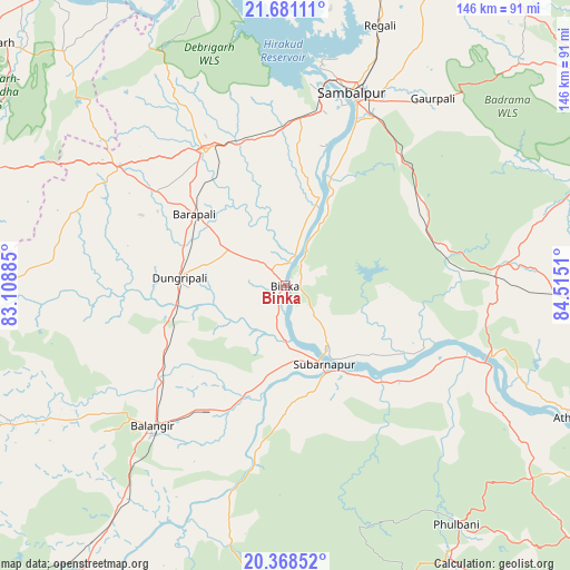
Binka GPS coordinates[2]
21° 1' 34.536" North, 83° 48' 43.092" East
| Map corner | latitude | longitude |
|---|---|---|
| Upper-left | 21.68111°, | 83.10885° |
| Center: | 21.02626°, | 83.81197° |
| Lower-right: | 20.36852°, | 84.5151° |
| Map W x H: | 145.9×145.9 km | = 90.7×90.7mi |
| max Lat: | 34.9274° ⇑61.6% North |
| Binka: | 21.02626° |
| min Lat: | ⇓38.4% South 8.09008° |
| min Long | Binka | max Long |
| 68.82655° | 83.81197° | 96.81° |
| W 81.5%⇐ | ⇒18.5% E |
Elevation
Elevation of Binka is 126 m = 413 ft, and this is 169.6 m = 556 ft below average elevation for this country.
| Max E: |
3681 m = 12077 ft | 64.2% |
| Avg. | 295.6 m = 970 ft | |
| Binka | 126 m = 413 ft | |
Min E: |
1 m = 3 ft | 35.8% |
See also: India elevation on elevation.city.
Geographical zone
Binka is located in North Torrid zone (between Equator and Tropic of Cancer). Distance of this Northern Tropic circle is 268 km =166.5 mi to North.| Distance of | km | miles | from Binka |
|---|---|---|---|
| North Pole | 7669.2 | 4765.4 | to North |
| Arctic Circle | 5063.3 | 3146.2 | to North |
| Tropic Cancer | 268 | 166.5 | to North |
| Equator | 2337.9 | 1452.7 | to South |


Nearby cities:
15 places around Binka: (largest is in red/bold)
• Balāngīr
49 km =30.4 mi,  223°
223°
• Bargarh
39.6 km =24.6 mi,  329°
329°
• Barpāli
29.6 km =18.4 mi,  307°
307°
• Baud
57.4 km =35.7 mi,  111°
111°
• Brājarājnagar
88.6 km =55.1 mi,  7°
7°
• Burla
54.1 km =33.6 mi, 6°
• Hīrākud
55.8 km =34.7 mi, 6°
• Kaintragarh
82.4 km =51.2 mi, 114°
• Padampur
77.8 km =48.3 mi,  267°
267°
• Patnāgarh
78.9 km =49 mi,  243°
243°
• Phulbāni
74.6 km =46.4 mi,  144°
144°
• Rengāli
73.3 km =45.5 mi,  19°
19°
• Sambalpur
51.7 km =32.1 mi, 19°
• Sonepur
24.1 km =15 mi,  153°
153°
• Tarabha
35.6 km =22.1 mi,  203°
203°
Sources, notices
• [Note1] Compared only with cities in India existing in our database
• [Src1] Map data: © OpenStreetMap contributors (CC-BY-SA)
• [Src2] Other city data from geonames.org with taken over terms of usage.
• [Src3] Geographical zone / Annual Mean Temperature by Robert A. Rohde @ Wikipedia
