Burla geodata
Burla (Odisha) is a populated place; located in India in Asia/Kolkata (GMT+5.5) time zone. With population of 40,816 people, there are 1083 cities with bigger population in this country. Compared to other cities in India, 59% of cities are located further ↑North; 81.6% of cities are located further ←West and 56.6% of cities have higher elevation than Burla. Note1


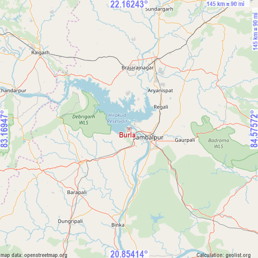
Burla GPS coordinates[2]
21° 30' 35.136" North, 83° 52' 21.324" East
| Map corner | latitude | longitude |
|---|---|---|
| Upper-left | 22.16243°, | 83.16947° |
| Center: | 21.50976°, | 83.87259° |
| Lower-right: | 20.85414°, | 84.57572° |
| Map W x H: | 145.5×145.5 km | = 90.4×90.4mi |
| max Lat: | 34.9274° ⇑59% North |
| Burla: | 21.50976° |
| min Lat: | ⇓41% South 8.09008° |
| min Long | Burla | max Long |
| 68.82655° | 83.87259° | 96.81° |
| W 81.6%⇐ | ⇒18.4% E |
Elevation
Elevation of Burla is 167 m = 548 ft, and this is 128.6 m = 422 ft below average elevation for this country.
| Max E: |
3681 m = 12077 ft | 56.6% |
| Avg. | 295.6 m = 970 ft | |
| Burla | 167 m = 548 ft | |
Min E: |
1 m = 3 ft | 43.4% |
See also: Burla elevation on elevation.city.
Geographical zone
Burla is located in North Torrid zone (between Equator and Tropic of Cancer). Distance of this Northern Tropic circle is 214.3 km =133.2 mi to North.| Distance of | km | miles | from Burla |
|---|---|---|---|
| North Pole | 7615.4 | 4732 | to North |
| Arctic Circle | 5009.5 | 3112.8 | to North |
| Tropic Cancer | 214.3 | 133.2 | to North |
| Equator | 2391.7 | 1486.1 | to South |


Nearby cities:
15 places around Burla: (largest is in red/bold)
• Bargarh
32.8 km =20.4 mi,  233°
233°
• Barpāli
46.2 km =28.7 mi,  219°
219°
• Baud
88.3 km =54.9 mi,  147°
147°
• Binka
54.1 km =33.6 mi,  186°
186°
• Brājarājnagar
34.4 km =21.4 mi,  7°
7°
• Hīrākud
1.7 km =1.1 mi,  0°
0°
• Jharsuguda
40.9 km =25.4 mi,  19°
19°
• Kuchinda
55.6 km =34.5 mi,  62°
62°
• Raigarh
65.4 km =40.6 mi,  311°
311°
• Rengāli
24 km =14.9 mi,  50°
50°
• Sambalpur
11.8 km =7.3 mi,  114°
114°
• Sonepur
75.4 km =46.9 mi,  176°
176°
• Sundargarh
69.5 km =43.2 mi, 13°
• Sārangarh
82.6 km =51.3 mi,  275°
275°
• Tarabha
88.8 km =55.2 mi, 193°
Sources, notices
• [Note1] Compared only with cities in India existing in our database
• [Src1] Map data: © OpenStreetMap contributors (CC-BY-SA)
• [Src2] Other city data from geonames.org with taken over terms of usage.
• [Src3] Geographical zone / Annual Mean Temperature by Robert A. Rohde @ Wikipedia
