Raigarh geodata
Raigarh (Chhattisgarh) is a populated place; located in India in Asia/Kolkata (GMT+5.5) time zone. With population of 121,278 people, there are 365 cities with bigger population in this country. Compared to other cities in India, 57.1% of cities are located further ↑North; 80.5% of cities are located further ←West and 54.5% of cities have lower elevation than Raigarh. Note1


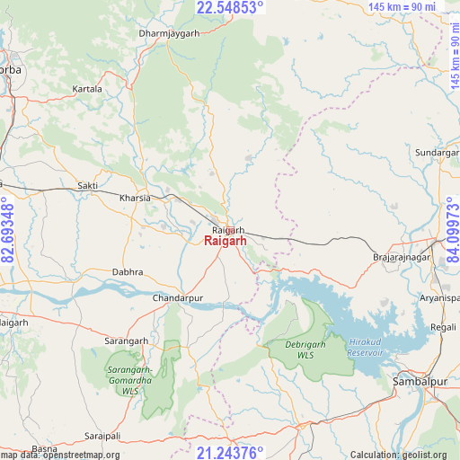
Raigarh GPS coordinates[2]
21° 53' 51.504" North, 83° 23' 47.76" East
| Map corner | latitude | longitude |
|---|---|---|
| Upper-left | 22.54853°, | 82.69348° |
| Center: | 21.89764°, | 83.3966° |
| Lower-right: | 21.24376°, | 84.09973° |
| Map W x H: | 145.1×145.1 km | = 90.2×90.2mi |
| max Lat: | 34.9274° ⇑57.1% North |
| Raigarh: | 21.89764° |
| min Lat: | ⇓42.9% South 8.09008° |
| min Long | Raigarh | max Long |
| 68.82655° | 83.3966° | 96.81° |
| W 80.5%⇐ | ⇒19.5% E |
Elevation
Elevation of Raigarh is 224 m = 735 ft, and this is 71.6 m = 235 ft below average elevation for this country.
| Max E: |
3681 m = 12077 ft | 45.5% |
| Avg. | 295.6 m = 970 ft | |
| Raigarh | 224 m = 735 ft | |
Min E: |
1 m = 3 ft | 54.5% |
See also: Raigarh elevation on elevation.city.
Geographical zone
Raigarh is located in North Torrid zone (between Equator and Tropic of Cancer). Distance of this Northern Tropic circle is 171.1 km =106.3 mi to North.| Distance of | km | miles | from Raigarh |
|---|---|---|---|
| North Pole | 7572.3 | 4705.2 | to North |
| Arctic Circle | 4966.4 | 3086 | to North |
| Tropic Cancer | 171.1 | 106.3 | to North |
| Equator | 2434.8 | 1512.9 | to South |


Nearby cities:
15 places around Raigarh: (largest is in red/bold)
• Bargarh
66.8 km =41.5 mi,  159°
159°
• Brājarājnagar
54.4 km =33.8 mi,  99°
99°
• Burla
65.4 km =40.6 mi,  131°
131°
• Chāmpa
79.3 km =49.3 mi,  281°
281°
• Gharghoda
31.1 km =19.3 mi,  351°
351°
• Hīrākud
64.3 km =40 mi, 130°
• Jharsuguda
63.2 km =39.3 mi,  94°
94°
• Kharsia
31.8 km =19.8 mi,  288°
288°
• Pathalgaon
73.6 km =45.7 mi,  5°
5°
• Rengāli
73.3 km =45.5 mi,  112°
112°
• Saktī
47.2 km =29.3 mi, 287°
• Sambalpur
76.8 km =47.7 mi, 128°
• Saraipali
76.3 km =47.4 mi,  211°
211°
• Sundargarh
70 km =43.5 mi,  69°
69°
• Sārangarh
47.7 km =29.6 mi,  223°
223°
Sources, notices
• [Note1] Compared only with cities in India existing in our database
• [Src1] Map data: © OpenStreetMap contributors (CC-BY-SA)
• [Src2] Other city data from geonames.org with taken over terms of usage.
• [Src3] Geographical zone / Annual Mean Temperature by Robert A. Rohde @ Wikipedia
