Charkhi Dādri geodata
Charkhi Dādri (Haryana) is a seat of a second-order administrative division; located in India in Asia/Kolkata (GMT+5.5) time zone. With population of 50,558 people, there are 880 cities with bigger population in this country. Compared to other cities in India, 87.2% of cities are located further ↓South; 70.9% of cities are located further →East and 54.7% of cities have lower elevation than Charkhi Dādri. Note1


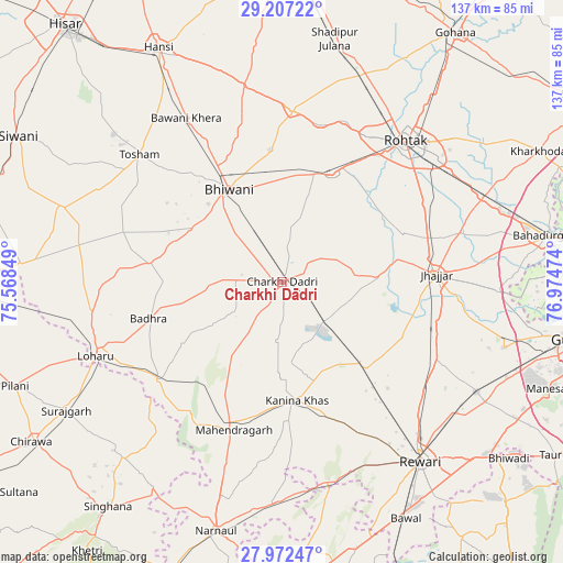
Charkhi Dādri GPS coordinates[2]
28° 35' 29.976" North, 76° 16' 17.796" East
| Map corner | latitude | longitude |
|---|---|---|
| Upper-left | 29.20722°, | 75.56849° |
| Center: | 28.59166°, | 76.27161° |
| Lower-right: | 27.97247°, | 76.97474° |
| Map W x H: | 137.3×137.3 km | = 85.3×85.3mi |
| max Lat: | 34.9274° ⇑12.8% North |
| Charkhi Dādri: | 28.59166° |
| min Lat: | ⇓87.2% South 8.09008° |
| min Long | Charkhi Dādri | max Long |
| 68.82655° | 76.27161° | 96.81° |
| W 29.1%⇐ | ⇒70.9% E |
Elevation
Elevation of Charkhi Dādri is 225 m = 738 ft, and this is 70.6 m = 232 ft below average elevation for this country.
| Max E: |
3681 m = 12077 ft | 45.3% |
| Avg. | 295.6 m = 970 ft | |
| Charkhi Dādri | 225 m = 738 ft | |
Min E: |
1 m = 3 ft | 54.7% |
See also: Charkhi Dādri elevation on elevation.city.
Geographical zone
Charkhi Dādri is located in North temperate zone (between Tropic of Cancer and the Arctic Circle). Distance of this Northern Tropic circle is 573.2 km =356.2 mi to South.| Distance of | km | miles | from Charkhi Dādri |
|---|---|---|---|
| North Pole | 6828 | 4242.7 | to North |
| Arctic Circle | 4222.1 | 2623.5 | to North |
| Tropic Cancer | 573.2 | 356.2 | to South |
| Equator | 3179.1 | 1975.4 | to South |


Nearby cities:
15 places around Charkhi Dādri: (largest is in red/bold)
• Ateli Mandi
54.6 km =33.9 mi,  181°
181°
• Beri Khās
32.2 km =20 mi,  67°
67°
• Bhiwāni
25.8 km =16 mi,  330°
330°
• Farrukhnagar
56.3 km =35 mi,  106°
106°
• Jhajjar
37.6 km =23.4 mi,  87°
87°
• Kalānaur
28.9 km =18 mi,  24°
24°
• Kanīna Khās
29.2 km =18.1 mi,  172°
172°
• Kheri Sāmpla
53.4 km =33.2 mi, 67°
• Lohāru
48.8 km =30.3 mi,  248°
248°
• Maham
42 km =26.1 mi,  3°
3°
• Mahendragarh
37.7 km =23.4 mi,  197°
197°
• Pataudi
57.7 km =35.9 mi,  120°
120°
• Rewāri
55.3 km =34.4 mi,  142°
142°
• Rohtak
45.7 km =28.4 mi,  42°
42°
• Toshām
46.4 km =28.8 mi,  311°
311°
Sources, notices
• [Note1] Compared only with cities in India existing in our database
• [Src1] Map data: © OpenStreetMap contributors (CC-BY-SA)
• [Src2] Other city data from geonames.org with taken over terms of usage.
• [Src3] Geographical zone / Annual Mean Temperature by Robert A. Rohde @ Wikipedia
