Rohtak geodata
Rohtak (Haryana) is a populated place; located in India in Asia/Kolkata (GMT+5.5) time zone. With population of 317,245 people, there are 138 cities with bigger population in this country. Compared to other cities in India, 88.7% of cities are located further ↓South; 67.3% of cities are located further →East and 54% of cities have lower elevation than Rohtak. Note1


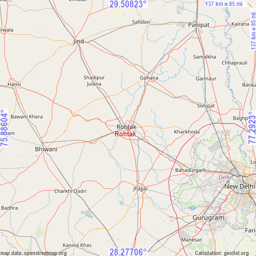
Rohtak GPS coordinates[2]
28° 53' 40.092" North, 76° 35' 21.012" East
| Map corner | latitude | longitude |
|---|---|---|
| Upper-left | 29.50823°, | 75.88604° |
| Center: | 28.89447°, | 76.58917° |
| Lower-right: | 28.27706°, | 77.2923° |
| Map W x H: | 136.9×136.9 km | = 85.1×85.1mi |
| max Lat: | 34.9274° ⇑11.3% North |
| Rohtak: | 28.89447° |
| min Lat: | ⇓88.7% South 8.09008° |
| min Long | Rohtak | max Long |
| 68.82655° | 76.58917° | 96.81° |
| W 32.7%⇐ | ⇒67.3% E |
Elevation
Elevation of Rohtak is 222 m = 728 ft, and this is 73.6 m = 241 ft below average elevation for this country.
| Max E: |
3681 m = 12077 ft | 46% |
| Avg. | 295.6 m = 970 ft | |
| Rohtak | 222 m = 728 ft | |
Min E: |
1 m = 3 ft | 54% |
See also: Rohtak elevation on elevation.city.
Geographical zone
Rohtak is located in North temperate zone (between Tropic of Cancer and the Arctic Circle). Distance of this Northern Tropic circle is 606.8 km =377 mi to South.| Distance of | km | miles | from Rohtak |
|---|---|---|---|
| North Pole | 6794.3 | 4221.8 | to North |
| Arctic Circle | 4188.4 | 2602.6 | to North |
| Tropic Cancer | 606.8 | 377 | to South |
| Equator | 3212.8 | 1996.3 | to South |


Nearby cities:
15 places around Rohtak: (largest is in red/bold)
• Bahādurgarh
40.5 km =25.2 mi,  123°
123°
• Bawāna
44.7 km =27.8 mi,  103°
103°
• Beri Khās
21.5 km =13.4 mi,  183°
183°
• Bhiwāni
45.2 km =28.1 mi,  255°
255°
• Charkhi Dādri
45.7 km =28.4 mi,  222°
222°
• Gohāna
29.2 km =18.1 mi,  22°
22°
• Jhajjar
32.7 km =20.3 mi,  168°
168°
• Kalānaur
20.2 km =12.6 mi,  248°
248°
• Kharkhauda
31.4 km =19.5 mi,  93°
93°
• Kheri Sāmpla
22.3 km =13.9 mi,  125°
125°
• Maham
29.8 km =18.5 mi,  286°
286°
• Narela
49.3 km =30.6 mi, 95°
• Rohini
49.6 km =30.8 mi,  109°
109°
• Shādīpur Julāna
31.1 km =19.3 mi,  324°
324°
• Sonīpat
43.3 km =26.9 mi,  75°
75°
Sources, notices
• [Note1] Compared only with cities in India existing in our database
• [Src1] Map data: © OpenStreetMap contributors (CC-BY-SA)
• [Src2] Other city data from geonames.org with taken over terms of usage.
• [Src3] Geographical zone / Annual Mean Temperature by Robert A. Rohde @ Wikipedia
