Kharkhauda geodata
Kharkhauda (Haryana) is a populated place; located in India in Asia/Kolkata (GMT+5.5) time zone. With population of 21,320 people, there are 1950 cities with bigger population in this country. Compared to other cities in India, 88.7% of cities are located further ↓South; 64.3% of cities are located further →East and 55.1% of cities have lower elevation than Kharkhauda. Note1


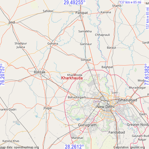
Kharkhauda GPS coordinates[2]
28° 52' 43.32" North, 76° 54' 38.484" East
| Map corner | latitude | longitude |
|---|---|---|
| Upper-left | 29.49255°, | 76.20757° |
| Center: | 28.8787°, | 76.91069° |
| Lower-right: | 28.2612°, | 77.61382° |
| Map W x H: | 136.9×136.9 km | = 85.1×85.1mi |
| max Lat: | 34.9274° ⇑11.3% North |
| Kharkhauda: | 28.8787° |
| min Lat: | ⇓88.7% South 8.09008° |
| min Long | Kharkhauda | max Long |
| 68.82655° | 76.91069° | 96.81° |
| W 35.7%⇐ | ⇒64.3% E |
Elevation
Elevation of Kharkhauda is 227 m = 745 ft, and this is 68.6 m = 225 ft below average elevation for this country.
| Max E: |
3681 m = 12077 ft | 44.9% |
| Avg. | 295.6 m = 970 ft | |
| Kharkhauda | 227 m = 745 ft | |
Min E: |
1 m = 3 ft | 55.1% |
See also: India elevation on elevation.city.
Geographical zone
Kharkhauda is located in North temperate zone (between Tropic of Cancer and the Arctic Circle). Distance of this Northern Tropic circle is 605.1 km =376 mi to South.| Distance of | km | miles | from Kharkhauda |
|---|---|---|---|
| North Pole | 6796.1 | 4222.9 | to North |
| Arctic Circle | 4190.2 | 2603.7 | to North |
| Tropic Cancer | 605.1 | 376 | to South |
| Equator | 3211 | 1995.2 | to South |


Nearby cities:
15 places around Kharkhauda: (largest is in red/bold)
• Alīpur
23.4 km =14.5 mi,  112°
112°
• Bahādurgarh
20.8 km =12.9 mi,  173°
173°
• Bawāna
15 km =9.3 mi,  126°
126°
• Bāghpat
30.9 km =19.2 mi,  76°
76°
• Gohāna
35.2 km =21.9 mi,  324°
324°
• Karol Bāgh
37.2 km =23.1 mi, 132°
• Khekra
36.4 km =22.6 mi,  92°
92°
• Kheri Sāmpla
17.3 km =10.7 mi,  229°
229°
• Najafgarh
30.7 km =19.1 mi, 167°
• Narela
18 km =11.2 mi,  99°
99°
• Nāngloi Jāt
26.9 km =16.7 mi,  145°
145°
• Pitampura
30.1 km =18.7 mi, 134°
• Rohini
21.5 km =13.4 mi, 134°
• Rohtak
31.4 km =19.5 mi,  273°
273°
• Sonīpat
16.7 km =10.4 mi,  39°
39°
Sources, notices
• [Note1] Compared only with cities in India existing in our database
• [Src1] Map data: © OpenStreetMap contributors (CC-BY-SA)
• [Src2] Other city data from geonames.org with taken over terms of usage.
• [Src3] Geographical zone / Annual Mean Temperature by Robert A. Rohde @ Wikipedia
