Bagalkot geodata
Bagalkot (Karnataka) is a populated place; located in India in Asia/Kolkata (GMT+5.5) time zone. With population of 97,269 people, there are 455 cities with bigger population in this country. Compared to other cities in India, 77.5% of cities are located further ↑North; 76.6% of cities are located further →East and 84% of cities have lower elevation than Bagalkot. Note1


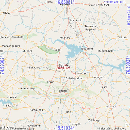
Bagalkot GPS coordinates[2]
16° 11' 12.228" North, 75° 41' 46.104" East
| Map corner | latitude | longitude |
|---|---|---|
| Upper-left | 16.86081°, | 74.99302° |
| Center: | 16.18673°, | 75.69614° |
| Lower-right: | 15.51034°, | 76.39927° |
| Map W x H: | 150.2×150.2 km | = 93.3×93.3mi |
| max Lat: | 34.9274° ⇑77.5% North |
| Bagalkot: | 16.18673° |
| min Lat: | ⇓22.5% South 8.09008° |
| min Long | Bagalkot | max Long |
| 68.82655° | 75.69614° | 96.81° |
| W 23.4%⇐ | ⇒76.6% E |
Elevation
Elevation of Bagalkot is 532 m = 1745 ft, and this is 236.4 m = 776 ft above average elevation for this country.
| Max E: |
3681 m = 12077 ft | 16% |
| Bagalkot | 532 m 1745 ft | |
| Avg. | 295.6 m = 970 ft | |
Min E: |
1 m = 3 ft | 84% |
See also: Bagalkot elevation on elevation.city.
Geographical zone
Bagalkot is located in North Torrid zone (between Equator and Tropic of Cancer). Distance of this Northern Tropic circle is 806.1 km =500.9 mi to North.| Distance of | km | miles | from Bagalkot |
|---|---|---|---|
| North Pole | 8207.3 | 5099.8 | to North |
| Arctic Circle | 5601.4 | 3480.5 | to North |
| Tropic Cancer | 806.1 | 500.9 | to North |
| Equator | 1799.8 | 1118.3 | to South |


Nearby cities:
15 places around Bagalkot: (largest is in red/bold)
• Basavana Bāgevādi
52.1 km =32.4 mi,  34°
34°
• Bilgi
19.7 km =12.2 mi,  334°
334°
• Bādāmi
30.3 km =18.8 mi,  183°
183°
• Gajendragarh
58 km =36 mi,  149°
149°
• Guledagudda
18.2 km =11.3 mi, 146°
• Hungund
41.1 km =25.5 mi,  109°
109°
• Ilkal
51.3 km =31.9 mi,  119°
119°
• Jamkhandi
55.8 km =34.7 mi,  309°
309°
• Kerūr
25 km =15.5 mi,  219°
219°
• Mahālingpur
66.6 km =41.4 mi,  289°
289°
• Muddebihāl
49.4 km =30.7 mi,  70°
70°
• Mudhol
47 km =29.2 mi, 290°
• Naregal
69.3 km =43.1 mi,  170°
170°
• Nargund
61.3 km =38.1 mi,  212°
212°
• Ron
54.3 km =33.7 mi, 175°
Sources, notices
• [Note1] Compared only with cities in India existing in our database
• [Src1] Map data: © OpenStreetMap contributors (CC-BY-SA)
• [Src2] Other city data from geonames.org with taken over terms of usage.
• [Src3] Geographical zone / Annual Mean Temperature by Robert A. Rohde @ Wikipedia
