Chiplūn geodata
Chiplūn (Maharashtra) is a populated place; located in India in Asia/Kolkata (GMT+5.5) time zone. With population of 51,437 people, there are 868 cities with bigger population in this country. Compared to other cities in India, 73.1% of cities are located further ↑North; 92.5% of cities are located further →East and 92.8% of cities have higher elevation than Chiplūn. Note1


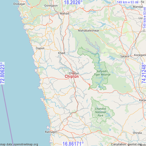
Chiplūn GPS coordinates[2]
17° 32' 0.204" North, 73° 30' 33.66" East
| Map corner | latitude | longitude |
|---|---|---|
| Upper-left | 18.2026°, | 72.80623° |
| Center: | 17.53339°, | 73.50935° |
| Lower-right: | 16.86171°, | 74.21248° |
| Map W x H: | 149.1×149.1 km | = 92.6×92.6mi |
| max Lat: | 34.9274° ⇑73.1% North |
| Chiplūn: | 17.53339° |
| min Lat: | ⇓26.9% South 8.09008° |
| min Long | Chiplūn | max Long |
| 68.82655° | 73.50935° | 96.81° |
| W 7.5%⇐ | ⇒92.5% E |
Elevation
Elevation of Chiplūn is 14 m = 46 ft, and this is 281.6 m = 924 ft below average elevation for this country.
| Max E: |
3681 m = 12077 ft | 92.8% |
| Avg. | 295.6 m = 970 ft | |
| Chiplūn | 14 m = 46 ft | |
Min E: |
1 m = 3 ft | 7.2% |
See also: Chiplūn elevation on elevation.city.
Geographical zone
Chiplūn is located in North Torrid zone (between Equator and Tropic of Cancer). Distance of this Northern Tropic circle is 656.4 km =407.9 mi to North.| Distance of | km | miles | from Chiplūn |
|---|---|---|---|
| North Pole | 8057.5 | 5006.7 | to North |
| Arctic Circle | 5451.6 | 3387.5 | to North |
| Tropic Cancer | 656.4 | 407.9 | to North |
| Equator | 1949.5 | 1211.4 | to South |


Nearby cities:
15 places around Chiplūn: (largest is in red/bold)
• Dābhol
35.5 km =22.1 mi,  280°
280°
• Goregaon
72.8 km =45.2 mi,  341°
341°
• Guhāgar
34 km =21.1 mi,  260°
260°
• Harnai
53.7 km =33.4 mi,  305°
305°
• Jalgaon
40.8 km =25.4 mi,  304°
304°
• Khed
23.8 km =14.8 mi,  329°
329°
• Koynanagar
31.1 km =19.3 mi,  118°
118°
• Mahābaleshwar
12 km =7.5 mi, 284°
• Mahād
61.9 km =38.5 mi,  350°
350°
• Mākhjan
29.3 km =18.2 mi,  181°
181°
• Pānchgani
53.3 km =33.1 mi,  35°
35°
• Pātan
45.2 km =28.1 mi,  112°
112°
• Ratnagiri
63.9 km =39.7 mi,  199°
199°
• Satara
54 km =33.6 mi,  71°
71°
• Wai
61.7 km =38.3 mi, 40°
Sources, notices
• [Note1] Compared only with cities in India existing in our database
• [Src1] Map data: © OpenStreetMap contributors (CC-BY-SA)
• [Src2] Other city data from geonames.org with taken over terms of usage.
• [Src3] Geographical zone / Annual Mean Temperature by Robert A. Rohde @ Wikipedia
