Nirmal geodata
Nirmal (Telangana) is a seat of a second-order administrative division; located in India in Asia/Kolkata (GMT+5.5) time zone. With population of 80,982 people, there are 539 cities with bigger population in this country. Compared to other cities in India, 68.3% of cities are located further ↑North; 52.7% of cities are located further ←West and 71.2% of cities have lower elevation than Nirmal. Note1


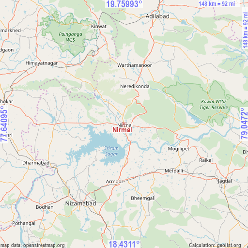
Nirmal GPS coordinates[2]
19° 5' 48.66" North, 78° 20' 38.652" East
| Map corner | latitude | longitude |
|---|---|---|
| Upper-left | 19.75993°, | 77.64095° |
| Center: | 19.09685°, | 78.34407° |
| Lower-right: | 18.4311°, | 79.0472° |
| Map W x H: | 147.8×147.8 km | = 91.8×91.8mi |
| max Lat: | 34.9274° ⇑68.3% North |
| Nirmal: | 19.09685° |
| min Lat: | ⇓31.7% South 8.09008° |
| min Long | Nirmal | max Long |
| 68.82655° | 78.34407° | 96.81° |
| W 52.7%⇐ | ⇒47.3% E |
Elevation
Elevation of Nirmal is 338 m = 1109 ft, and this is 42.4 m = 139 ft above average elevation for this country.
| Max E: |
3681 m = 12077 ft | 28.8% |
| Nirmal | 338 m 1109 ft | |
| Avg. | 295.6 m = 970 ft | |
Min E: |
1 m = 3 ft | 71.2% |
See also: Nirmal elevation on elevation.city.
Geographical zone
Nirmal is located in North Torrid zone (between Equator and Tropic of Cancer). Distance of this Northern Tropic circle is 482.5 km =299.8 mi to North.| Distance of | km | miles | from Nirmal |
|---|---|---|---|
| North Pole | 7883.7 | 4898.7 | to North |
| Arctic Circle | 5277.8 | 3279.5 | to North |
| Tropic Cancer | 482.5 | 299.8 | to North |
| Equator | 2123.4 | 1319.4 | to South |


Nearby cities:
15 places around Nirmal: (largest is in red/bold)
• Bhaisa
40 km =24.9 mi,  272°
272°
• Biloli
74.4 km =46.2 mi,  241°
241°
• Bodhan
68.3 km =42.4 mi,  224°
224°
• Dasnapur
64.4 km =40 mi,  15°
15°
• Dharmābād
56.8 km =35.3 mi,  246°
246°
• Hadgāon
84.5 km =52.5 mi,  301°
301°
• Jagtiāl
68.9 km =42.8 mi,  119°
119°
• Kinwat
60.7 km =37.7 mi,  345°
345°
• Kondalwādi
68.4 km =42.5 mi, 241°
• Koratla
49.3 km =30.6 mi,  128°
128°
• Kyathampalle
66.4 km =41.3 mi, 16°
• Kāmāreddi
86.4 km =53.7 mi,  180°
180°
• Mudkhed
88.6 km =55.1 mi, 274°
• Nizāmābād
53.9 km =33.5 mi,  208°
208°
• Ādilābād
67 km =41.6 mi, 17°
Sources, notices
• [Note1] Compared only with cities in India existing in our database
• [Src1] Map data: © OpenStreetMap contributors (CC-BY-SA)
• [Src2] Other city data from geonames.org with taken over terms of usage.
• [Src3] Geographical zone / Annual Mean Temperature by Robert A. Rohde @ Wikipedia
