Hosdurga geodata
Hosdurga (Karnataka) is a populated place; located in India in Asia/Kolkata (GMT+5.5) time zone. With population of 24,685 people, there are 1725 cities with bigger population in this country. Compared to other cities in India, 83.6% of cities are located further ↑North; 70.8% of cities are located further →East and 92.7% of cities have lower elevation than Hosdurga. Note1


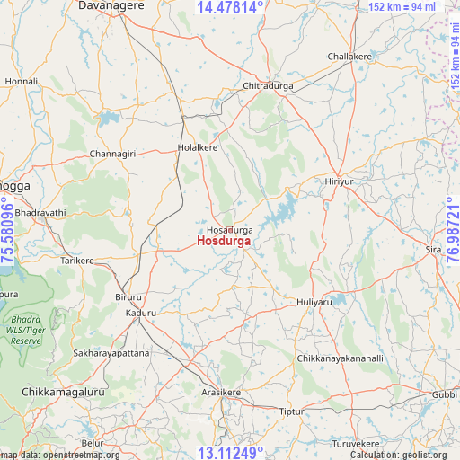
Hosdurga GPS coordinates[2]
13° 47' 46.716" North, 76° 17' 2.688" East
| Map corner | latitude | longitude |
|---|---|---|
| Upper-left | 14.47814°, | 75.58096° |
| Center: | 13.79631°, | 76.28408° |
| Lower-right: | 13.11249°, | 76.98721° |
| Map W x H: | 151.8×151.8 km | = 94.3×94.3mi |
| max Lat: | 34.9274° ⇑83.6% North |
| Hosdurga: | 13.79631° |
| min Lat: | ⇓16.4% South 8.09008° |
| min Long | Hosdurga | max Long |
| 68.82655° | 76.28408° | 96.81° |
| W 29.2%⇐ | ⇒70.8% E |
Elevation
Elevation of Hosdurga is 729 m = 2392 ft, and this is 433.4 m = 1422 ft above average elevation for this country.
| Max E: |
3681 m = 12077 ft | 7.3% |
| Hosdurga | 729 m 2392 ft | |
| Avg. | 295.6 m = 970 ft | |
Min E: |
1 m = 3 ft | 92.7% |
See also: India elevation on elevation.city.
Geographical zone
Hosdurga is located in North Torrid zone (between Equator and Tropic of Cancer). Distance of this Northern Tropic circle is 1071.9 km =666 mi to North.| Distance of | km | miles | from Hosdurga |
|---|---|---|---|
| North Pole | 8473.1 | 5264.9 | to North |
| Arctic Circle | 5867.2 | 3645.7 | to North |
| Tropic Cancer | 1071.9 | 666 | to North |
| Equator | 1534 | 953.2 | to South |


Nearby cities:
15 places around Hosdurga: (largest is in red/bold)
• Ajjampur
30.9 km =19.2 mi,  255°
255°
• Arsikere
53.7 km =33.4 mi,  183°
183°
• Bhadrāvati
62.8 km =39 mi,  275°
275°
• Birūr
40.4 km =25.1 mi,  236°
236°
• Bānāvar
44.9 km =27.9 mi,  196°
196°
• Channagiri
46.2 km =28.7 mi,  303°
303°
• Chiknāyakanhalli
55.8 km =34.7 mi,  139°
139°
• Chitradurga
49 km =30.4 mi,  14°
14°
• Hiriyūr
39.6 km =24.6 mi,  65°
65°
• Holalkere
29.4 km =18.3 mi,  338°
338°
• Kadūr
40 km =24.9 mi,  227°
227°
• Māyakonda
58.9 km =36.6 mi, 338°
• Sīra
67.3 km =41.8 mi,  95°
95°
• Tarikere
51.7 km =32.1 mi, 259°
• Tiptūr
63.6 km =39.5 mi,  160°
160°
Sources, notices
• [Note1] Compared only with cities in India existing in our database
• [Src1] Map data: © OpenStreetMap contributors (CC-BY-SA)
• [Src2] Other city data from geonames.org with taken over terms of usage.
• [Src3] Geographical zone / Annual Mean Temperature by Robert A. Rohde @ Wikipedia
