Chitradurga geodata
Chitradurga (Karnataka) is a populated place; located in India in Asia/Kolkata (GMT+5.5) time zone. With population of 138,587 people, there are 313 cities with bigger population in this country. Compared to other cities in India, 82.9% of cities are located further ↑North; 69.1% of cities are located further →East and 93% of cities have lower elevation than Chitradurga. Note1


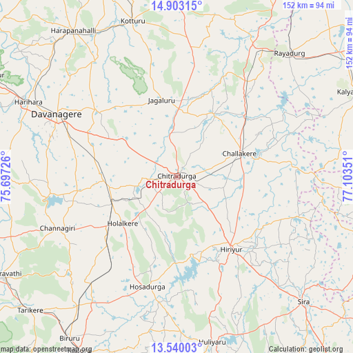
Chitradurga GPS coordinates[2]
14° 13' 21.432" North, 76° 24' 1.368" East
| Map corner | latitude | longitude |
|---|---|---|
| Upper-left | 14.90315°, | 75.69726° |
| Center: | 14.22262°, | 76.40038° |
| Lower-right: | 13.54003°, | 77.10351° |
| Map W x H: | 151.6×151.6 km | = 94.2×94.2mi |
| max Lat: | 34.9274° ⇑82.9% North |
| Chitradurga: | 14.22262° |
| min Lat: | ⇓17.1% South 8.09008° |
| min Long | Chitradurga | max Long |
| 68.82655° | 76.40038° | 96.81° |
| W 30.9%⇐ | ⇒69.1% E |
Elevation
Elevation of Chitradurga is 747 m = 2451 ft, and this is 451.4 m = 1481 ft above average elevation for this country.
| Max E: |
3681 m = 12077 ft | 7% |
| Chitradurga | 747 m 2451 ft | |
| Avg. | 295.6 m = 970 ft | |
Min E: |
1 m = 3 ft | 93% |
See also: Chitradurga elevation on elevation.city.
Geographical zone
Chitradurga is located in North Torrid zone (between Equator and Tropic of Cancer). Distance of this Northern Tropic circle is 1024.5 km =636.6 mi to North.| Distance of | km | miles | from Chitradurga |
|---|---|---|---|
| North Pole | 8425.7 | 5235.5 | to North |
| Arctic Circle | 5819.8 | 3616.3 | to North |
| Tropic Cancer | 1024.5 | 636.6 | to North |
| Equator | 1581.4 | 982.6 | to South |


Nearby cities:
15 places around Chitradurga: (largest is in red/bold)
• Ajjampur
69.5 km =43.2 mi,  217°
217°
• Challakere
29.1 km =18.1 mi,  68°
68°
• Channagiri
55.7 km =34.6 mi,  246°
246°
• Davangere
57.8 km =35.9 mi,  298°
298°
• Harihar
71.6 km =44.5 mi, 296°
• Harpanahalli
76.9 km =47.8 mi,  324°
324°
• Hiriyūr
38.8 km =24.1 mi,  142°
142°
• Holalkere
30.6 km =19 mi,  229°
229°
• Hosdurga
49 km =30.4 mi,  194°
194°
• Jagalūr
33.7 km =20.9 mi,  348°
348°
• Kottūru
69.7 km =43.3 mi,  343°
343°
• Kūdligi
75.9 km =47.2 mi,  358°
358°
• Māyakonda
35 km =21.7 mi,  282°
282°
• Rāyadrug
72 km =44.7 mi,  42°
42°
• Sīra
76.3 km =47.4 mi,  134°
134°
Sources, notices
• [Note1] Compared only with cities in India existing in our database
• [Src1] Map data: © OpenStreetMap contributors (CC-BY-SA)
• [Src2] Other city data from geonames.org with taken over terms of usage.
• [Src3] Geographical zone / Annual Mean Temperature by Robert A. Rohde @ Wikipedia
