Hiriyūr geodata
Hiriyūr (Karnataka) is a populated place; located in India in Asia/Kolkata (GMT+5.5) time zone. With population of 53,519 people, there are 827 cities with bigger population in this country. Compared to other cities in India, 83.4% of cities are located further ↑North; 67.1% of cities are located further →East and 88.7% of cities have lower elevation than Hiriyūr. Note1


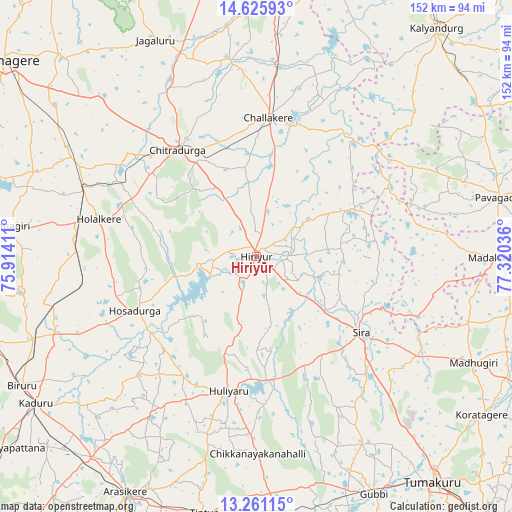
Hiriyūr GPS coordinates[2]
13° 56' 40.38" North, 76° 37' 2.028" East
| Map corner | latitude | longitude |
|---|---|---|
| Upper-left | 14.62593°, | 75.91411° |
| Center: | 13.94455°, | 76.61723° |
| Lower-right: | 13.26115°, | 77.32036° |
| Map W x H: | 151.7×151.8 km | = 94.3×94.3mi |
| max Lat: | 34.9274° ⇑83.4% North |
| Hiriyūr: | 13.94455° |
| min Lat: | ⇓16.6% South 8.09008° |
| min Long | Hiriyūr | max Long |
| 68.82655° | 76.61723° | 96.81° |
| W 32.9%⇐ | ⇒67.1% E |
Elevation
Elevation of Hiriyūr is 607 m = 1991 ft, and this is 311.4 m = 1022 ft above average elevation for this country.
| Max E: |
3681 m = 12077 ft | 11.3% |
| Hiriyūr | 607 m 1991 ft | |
| Avg. | 295.6 m = 970 ft | |
Min E: |
1 m = 3 ft | 88.7% |
See also: Hiriyūr elevation on elevation.city.
Geographical zone
Hiriyūr is located in North Torrid zone (between Equator and Tropic of Cancer). Distance of this Northern Tropic circle is 1055.4 km =655.8 mi to North.| Distance of | km | miles | from Hiriyūr |
|---|---|---|---|
| North Pole | 8456.6 | 5254.7 | to North |
| Arctic Circle | 5850.7 | 3635.5 | to North |
| Tropic Cancer | 1055.4 | 655.8 | to North |
| Equator | 1550.5 | 963.4 | to South |


Nearby cities:
15 places around Hiriyūr: (largest is in red/bold)
• Ajjampur
70.2 km =43.6 mi,  249°
249°
• Bānāvar
77 km =47.8 mi,  219°
219°
• Challakere
41.7 km =25.9 mi,  5°
5°
• Channagiri
75.1 km =46.7 mi,  276°
276°
• Chiknāyakanhalli
58.8 km =36.5 mi,  179°
179°
• Chitradurga
38.8 km =24.1 mi,  322°
322°
• Holalkere
47.9 km =29.8 mi, 283°
• Hosakote
69.9 km =43.4 mi,  58°
58°
• Hosdurga
39.6 km =24.6 mi, 245°
• Jagalūr
70.6 km =43.9 mi,  334°
334°
• Maddagiri
71.6 km =44.5 mi,  116°
116°
• Māyakonda
69.2 km =43 mi,  303°
303°
• Pāvugada
73.6 km =45.7 mi,  76°
76°
• Sīra
38.3 km =23.8 mi,  126°
126°
• Tiptūr
78 km =48.5 mi,  191°
191°
Sources, notices
• [Note1] Compared only with cities in India existing in our database
• [Src1] Map data: © OpenStreetMap contributors (CC-BY-SA)
• [Src2] Other city data from geonames.org with taken over terms of usage.
• [Src3] Geographical zone / Annual Mean Temperature by Robert A. Rohde @ Wikipedia
