Hatta geodata
Hatta (Madhya Pradesh) is a populated place; located in India in Asia/Kolkata (GMT+5.5) time zone. With population of 30,854 people, there are 1408 cities with bigger population in this country. Compared to other cities in India, 58.7% of cities are located further ↓South; 64.8% of cities are located further ←West and 70.9% of cities have lower elevation than Hatta. Note1


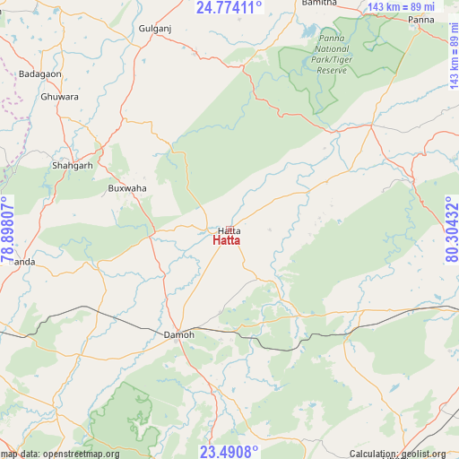
Hatta GPS coordinates[2]
24° 8' 2.616" North, 79° 36' 4.284" East
| Map corner | latitude | longitude |
|---|---|---|
| Upper-left | 24.77411°, | 78.89807° |
| Center: | 24.13406°, | 79.60119° |
| Lower-right: | 23.4908°, | 80.30432° |
| Map W x H: | 142.7×142.7 km | = 88.7×88.7mi |
| max Lat: | 34.9274° ⇑41.3% North |
| Hatta: | 24.13406° |
| min Lat: | ⇓58.7% South 8.09008° |
| min Long | Hatta | max Long |
| 68.82655° | 79.60119° | 96.81° |
| W 64.8%⇐ | ⇒35.2% E |
Elevation
Elevation of Hatta is 336 m = 1102 ft, and this is 40.4 m = 133 ft above average elevation for this country.
| Max E: |
3681 m = 12077 ft | 29.1% |
| Hatta | 336 m 1102 ft | |
| Avg. | 295.6 m = 970 ft | |
Min E: |
1 m = 3 ft | 70.9% |
See also: India elevation on elevation.city.
Geographical zone
Hatta is located in North temperate zone (between Tropic of Cancer and the Arctic Circle). Distance of this Northern Tropic circle is 77.5 km =48.2 mi to South.| Distance of | km | miles | from Hatta |
|---|---|---|---|
| North Pole | 7323.6 | 4550.7 | to North |
| Arctic Circle | 4717.7 | 2931.4 | to North |
| Tropic Cancer | 77.5 | 48.2 | to South |
| Equator | 2683.5 | 1667.4 | to South |


Nearby cities:
15 places around Hatta: (largest is in red/bold)
• Amānganj
54.8 km =34.1 mi,  53°
53°
• Bakshwāho
34.5 km =21.4 mi,  292°
292°
• Banda
65.7 km =40.8 mi,  261°
261°
• Bijāwar
55.6 km =34.5 mi,  348°
348°
• Damoh
37.2 km =23.1 mi,  205°
205°
• Garhākota
61 km =37.9 mi,  229°
229°
• Hindoria
25.9 km =16.1 mi,  187°
187°
• Karrāpur
77.5 km =48.2 mi,  254°
254°
• Katangi
79.5 km =49.4 mi,  165°
165°
• Majholi
77.7 km =48.3 mi,  154°
154°
• Patharia
48.9 km =30.4 mi,  237°
237°
• Pawai
58.7 km =36.5 mi,  75°
75°
• Rehli
77.8 km =48.3 mi,  224°
224°
• Shāhgarh
52.9 km =32.9 mi, 292°
• Shāhpur
62 km =38.5 mi, 244°
Sources, notices
• [Note1] Compared only with cities in India existing in our database
• [Src1] Map data: © OpenStreetMap contributors (CC-BY-SA)
• [Src2] Other city data from geonames.org with taken over terms of usage.
• [Src3] Geographical zone / Annual Mean Temperature by Robert A. Rohde @ Wikipedia
