Damoh geodata
Damoh (Madhya Pradesh) is a populated place; located in India in Asia/Kolkata (GMT+5.5) time zone. With population of 118,776 people, there are 370 cities with bigger population in this country. Compared to other cities in India, 57.1% of cities are located further ↓South; 63.1% of cities are located further ←West and 74.4% of cities have lower elevation than Damoh. Note1


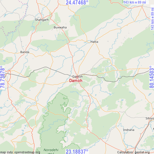
Damoh GPS coordinates[2]
23° 49' 59.232" North, 79° 26' 30.84" East
| Map corner | latitude | longitude |
|---|---|---|
| Upper-left | 24.47468°, | 78.73878° |
| Center: | 23.83312°, | 79.4419° |
| Lower-right: | 23.18837°, | 80.14503° |
| Map W x H: | 143×143 km | = 88.9×88.9mi |
| max Lat: | 34.9274° ⇑42.9% North |
| Damoh: | 23.83312° |
| min Lat: | ⇓57.1% South 8.09008° |
| min Long | Damoh | max Long |
| 68.82655° | 79.4419° | 96.81° |
| W 63.1%⇐ | ⇒36.9% E |
Elevation
Elevation of Damoh is 378 m = 1240 ft, and this is 82.4 m = 270 ft above average elevation for this country.
| Max E: |
3681 m = 12077 ft | 25.6% |
| Damoh | 378 m 1240 ft | |
| Avg. | 295.6 m = 970 ft | |
Min E: |
1 m = 3 ft | 74.4% |
See also: Damoh elevation on elevation.city.
Geographical zone
Damoh is located in North temperate zone (between Tropic of Cancer and the Arctic Circle). Distance of this Northern Tropic circle is 44.1 km =27.4 mi to South.| Distance of | km | miles | from Damoh |
|---|---|---|---|
| North Pole | 7357.1 | 4571.5 | to North |
| Arctic Circle | 4751.2 | 2952.3 | to North |
| Tropic Cancer | 44.1 | 27.4 | to South |
| Equator | 2650 | 1646.6 | to South |


Nearby cities:
15 places around Damoh: (largest is in red/bold)
• Bakshwāho
49.1 km =30.5 mi,  341°
341°
• Banda
54.3 km =33.7 mi,  295°
295°
• Dhāna
59.7 km =37.1 mi,  260°
260°
• Garhākota
31 km =19.3 mi, 258°
• Hatta
37.2 km =23.1 mi,  25°
25°
• Hindoria
15.1 km =9.4 mi,  58°
58°
• Kaimori
58.6 km =36.4 mi,  148°
148°
• Karrāpur
60 km =37.3 mi,  282°
282°
• Katangi
56.6 km =35.2 mi,  140°
140°
• Majholi
61.4 km =38.2 mi,  126°
126°
• Patharia
26.3 km =16.3 mi,  286°
286°
• Rehli
44.3 km =27.5 mi,  240°
240°
• Shāhgarh
62.7 km =39 mi,  328°
328°
• Shāhpur
40.3 km =25 mi, 279°
• Tendūkheda
49.6 km =30.8 mi,  168°
168°
Sources, notices
• [Note1] Compared only with cities in India existing in our database
• [Src1] Map data: © OpenStreetMap contributors (CC-BY-SA)
• [Src2] Other city data from geonames.org with taken over terms of usage.
• [Src3] Geographical zone / Annual Mean Temperature by Robert A. Rohde @ Wikipedia
