Majholi geodata
Majholi (Madhya Pradesh) is a populated place; located in India in Asia/Kolkata (GMT+5.5) time zone. With population of 11,553 people, there are 2775 cities with bigger population in this country. Compared to other cities in India, 54.9% of cities are located further ↓South; 67.2% of cities are located further ←West and 75.6% of cities have lower elevation than Majholi. Note1


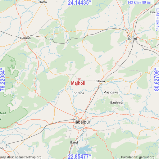
Majholi GPS coordinates[2]
23° 30' 4.104" North, 79° 55' 26.256" East
| Map corner | latitude | longitude |
|---|---|---|
| Upper-left | 24.14435°, | 79.22084° |
| Center: | 23.50114°, | 79.92396° |
| Lower-right: | 22.85477°, | 80.62709° |
| Map W x H: | 143.4×143.4 km | = 89.1×89.1mi |
| max Lat: | 34.9274° ⇑45.1% North |
| Majholi: | 23.50114° |
| min Lat: | ⇓54.9% South 8.09008° |
| min Long | Majholi | max Long |
| 68.82655° | 79.92396° | 96.81° |
| W 67.2%⇐ | ⇒32.8% E |
Elevation
Elevation of Majholi is 394 m = 1293 ft, and this is 98.4 m = 323 ft above average elevation for this country.
| Max E: |
3681 m = 12077 ft | 24.4% |
| Majholi | 394 m 1293 ft | |
| Avg. | 295.6 m = 970 ft | |
Min E: |
1 m = 3 ft | 75.6% |
See also: India elevation on elevation.city.
Geographical zone
Majholi is located in North temperate zone (between Tropic of Cancer and the Arctic Circle). Distance of this Northern Tropic circle is 7.2 km =4.5 mi to South.| Distance of | km | miles | from Majholi |
|---|---|---|---|
| North Pole | 7394 | 4594.4 | to North |
| Arctic Circle | 4788.1 | 2975.2 | to North |
| Tropic Cancer | 7.2 | 4.5 | to South |
| Equator | 2613.1 | 1623.7 | to South |


Nearby cities:
15 places around Majholi: (largest is in red/bold)
• Barela
46.8 km =29.1 mi,  163°
163°
• Bargi
56.9 km =35.4 mi,  184°
184°
• Damoh
61.4 km =38.2 mi,  306°
306°
• Hatta
77.7 km =48.3 mi,  334°
334°
• Hindoria
57.5 km =35.7 mi,  321°
321°
• Jabalpur
37.3 km =23.2 mi, 175°
• Kaimori
22.5 km =14 mi,  234°
234°
• Katangi
14.6 km =9.1 mi,  242°
242°
• Khamaria
31 km =19.3 mi,  188°
188°
• Murwāra
60.8 km =37.8 mi,  51°
51°
• Panāgar
25.1 km =15.6 mi, 163°
• Pātan
33.8 km =21 mi, 225°
• Shāhpura
48.4 km =30.1 mi,  213°
213°
• Sihorā
18.4 km =11.4 mi,  94°
94°
• Tendūkheda
40.9 km =25.4 mi,  253°
253°
Sources, notices
• [Note1] Compared only with cities in India existing in our database
• [Src1] Map data: © OpenStreetMap contributors (CC-BY-SA)
• [Src2] Other city data from geonames.org with taken over terms of usage.
• [Src3] Geographical zone / Annual Mean Temperature by Robert A. Rohde @ Wikipedia
