Bakshwāho geodata
Bakshwāho (Madhya Pradesh) is a populated place; located in India in Asia/Kolkata (GMT+5.5) time zone. With population of 9,734 people, there are 2973 cities with bigger population in this country. Compared to other cities in India, 59.3% of cities are located further ↓South; 61.7% of cities are located further ←West and 82.4% of cities have lower elevation than Bakshwāho. Note1


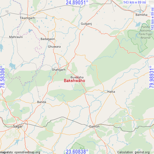
Bakshwāho GPS coordinates[2]
24° 15' 3.816" North, 79° 17' 10.248" East
| Map corner | latitude | longitude |
|---|---|---|
| Upper-left | 24.89051°, | 78.58306° |
| Center: | 24.25106°, | 79.28618° |
| Lower-right: | 23.60838°, | 79.98931° |
| Map W x H: | 142.6×142.6 km | = 88.6×88.6mi |
| max Lat: | 34.9274° ⇑40.7% North |
| Bakshwāho: | 24.25106° |
| min Lat: | ⇓59.3% South 8.09008° |
| min Long | Bakshwāho | max Long |
| 68.82655° | 79.28618° | 96.81° |
| W 61.7%⇐ | ⇒38.3% E |
Elevation
Elevation of Bakshwāho is 499 m = 1637 ft, and this is 203.4 m = 667 ft above average elevation for this country.
| Max E: |
3681 m = 12077 ft | 17.6% |
| Bakshwāho | 499 m 1637 ft | |
| Avg. | 295.6 m = 970 ft | |
Min E: |
1 m = 3 ft | 82.4% |
See also: India elevation on elevation.city.
Geographical zone
Bakshwāho is located in North temperate zone (between Tropic of Cancer and the Arctic Circle). Distance of this Northern Tropic circle is 90.5 km =56.2 mi to South.| Distance of | km | miles | from Bakshwāho |
|---|---|---|---|
| North Pole | 7310.6 | 4542.6 | to North |
| Arctic Circle | 4704.7 | 2923.4 | to North |
| Tropic Cancer | 90.5 | 56.2 | to South |
| Equator | 2696.5 | 1675.5 | to South |


Nearby cities:
15 places around Bakshwāho: (largest is in red/bold)
• Baldeogarh
60.4 km =37.5 mi,  338°
338°
• Banda
40.2 km =25 mi,  235°
235°
• Bijāwar
46.3 km =28.8 mi,  26°
26°
• Damoh
49.1 km =30.5 mi,  161°
161°
• Dhāna
70.7 km =43.9 mi,  217°
217°
• Garhākota
54.4 km =33.8 mi,  195°
195°
• Hatta
34.5 km =21.4 mi,  112°
112°
• Hindoria
48.1 km =29.9 mi,  143°
143°
• Karrāpur
54.3 km =33.7 mi,  231°
231°
• Khargāpur
65.2 km =40.5 mi,  347°
347°
• Mahroni
67.7 km =42.1 mi,  303°
303°
• Patharia
40.2 km =25 mi,  193°
193°
• Shāhgarh
18.4 km =11.4 mi,  292°
292°
• Shāhpur
46.4 km =28.8 mi,  211°
211°
• Tīkamgarh
71.6 km =44.5 mi,  319°
319°
Sources, notices
• [Note1] Compared only with cities in India existing in our database
• [Src1] Map data: © OpenStreetMap contributors (CC-BY-SA)
• [Src2] Other city data from geonames.org with taken over terms of usage.
• [Src3] Geographical zone / Annual Mean Temperature by Robert A. Rohde @ Wikipedia
