Bijāwar geodata
Bijāwar (Madhya Pradesh) is a populated place; located in India in Asia/Kolkata (GMT+5.5) time zone. With population of 19,468 people, there are 2075 cities with bigger population in this country. Compared to other cities in India, 61.4% of cities are located further ↓South; 63.6% of cities are located further ←West and 72.8% of cities have lower elevation than Bijāwar. Note1


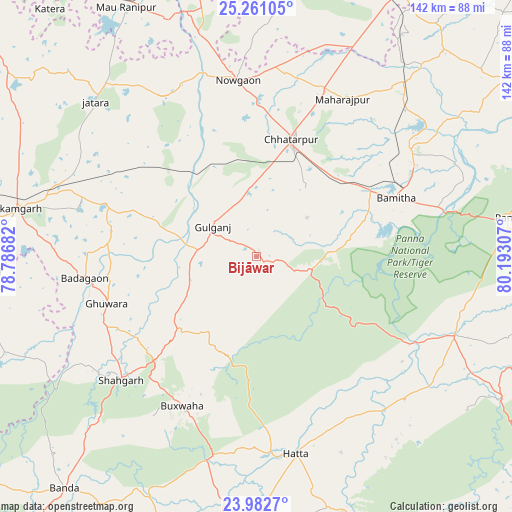
Bijāwar GPS coordinates[2]
24° 37' 24.636" North, 79° 29' 23.784" East
| Map corner | latitude | longitude |
|---|---|---|
| Upper-left | 25.26105°, | 78.78682° |
| Center: | 24.62351°, | 79.48994° |
| Lower-right: | 23.9827°, | 80.19307° |
| Map W x H: | 142.1×142.1 km | = 88.3×88.3mi |
| max Lat: | 34.9274° ⇑38.6% North |
| Bijāwar: | 24.62351° |
| min Lat: | ⇓61.4% South 8.09008° |
| min Long | Bijāwar | max Long |
| 68.82655° | 79.48994° | 96.81° |
| W 63.6%⇐ | ⇒36.4% E |
Elevation
Elevation of Bijāwar is 360 m = 1181 ft, and this is 64.4 m = 211 ft above average elevation for this country.
| Max E: |
3681 m = 12077 ft | 27.2% |
| Bijāwar | 360 m 1181 ft | |
| Avg. | 295.6 m = 970 ft | |
Min E: |
1 m = 3 ft | 72.8% |
See also: India elevation on elevation.city.
Geographical zone
Bijāwar is located in North temperate zone (between Tropic of Cancer and the Arctic Circle). Distance of this Northern Tropic circle is 132 km =82 mi to South.| Distance of | km | miles | from Bijāwar |
|---|---|---|---|
| North Pole | 7269.2 | 4516.9 | to North |
| Arctic Circle | 4663.3 | 2897.6 | to North |
| Tropic Cancer | 132 | 82 | to South |
| Equator | 2737.9 | 1701.3 | to South |


Nearby cities:
15 places around Bijāwar: (largest is in red/bold)
• Amānganj
59.4 km =36.9 mi,  111°
111°
• Bakshwāho
46.3 km =28.8 mi,  206°
206°
• Baldeogarh
45.2 km =28.1 mi,  289°
289°
• Chhatarpur
34.2 km =21.3 mi,  16°
16°
• Harpālpur
75.5 km =46.9 mi,  347°
347°
• Hatta
55.6 km =34.5 mi,  168°
168°
• Jatāra
61.9 km =38.5 mi,  313°
313°
• Khajuraho Group of Monuments
51.3 km =31.9 mi,  60°
60°
• Khargāpur
41.4 km =25.7 mi,  302°
302°
• Mahroni
77.2 km =48 mi,  266°
266°
• Palera
51.4 km =31.9 mi,  329°
329°
• Panna
71.3 km =44.3 mi,  81°
81°
• Rājnagar
51.8 km =32.2 mi, 55°
• Shāhgarh
51 km =31.7 mi,  227°
227°
• Tīkamgarh
67.9 km =42.2 mi,  281°
281°
Sources, notices
• [Note1] Compared only with cities in India existing in our database
• [Src1] Map data: © OpenStreetMap contributors (CC-BY-SA)
• [Src2] Other city data from geonames.org with taken over terms of usage.
• [Src3] Geographical zone / Annual Mean Temperature by Robert A. Rohde @ Wikipedia
