Shāhgarh geodata
Shāhgarh (Madhya Pradesh) is a populated place; located in India in Asia/Kolkata (GMT+5.5) time zone. With population of 14,830 people, there are 2480 cities with bigger population in this country. Compared to other cities in India, 59.6% of cities are located further ↓South; 60.1% of cities are located further ←West and 75.2% of cities have lower elevation than Shāhgarh. Note1


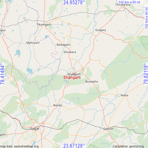
Shāhgarh GPS coordinates[2]
24° 18' 49.14" North, 79° 7' 5.016" East
| Map corner | latitude | longitude |
|---|---|---|
| Upper-left | 24.95278°, | 78.41494° |
| Center: | 24.31365°, | 79.11806° |
| Lower-right: | 23.67128°, | 79.82119° |
| Map W x H: | 142.5×142.5 km | = 88.5×88.5mi |
| max Lat: | 34.9274° ⇑40.4% North |
| Shāhgarh: | 24.31365° |
| min Lat: | ⇓59.6% South 8.09008° |
| min Long | Shāhgarh | max Long |
| 68.82655° | 79.11806° | 96.81° |
| W 60.1%⇐ | ⇒39.9% E |
Elevation
Elevation of Shāhgarh is 389 m = 1276 ft, and this is 93.4 m = 306 ft above average elevation for this country.
| Max E: |
3681 m = 12077 ft | 24.8% |
| Shāhgarh | 389 m 1276 ft | |
| Avg. | 295.6 m = 970 ft | |
Min E: |
1 m = 3 ft | 75.2% |
See also: India elevation on elevation.city.
Geographical zone
Shāhgarh is located in North temperate zone (between Tropic of Cancer and the Arctic Circle). Distance of this Northern Tropic circle is 97.5 km =60.6 mi to South.| Distance of | km | miles | from Shāhgarh |
|---|---|---|---|
| North Pole | 7303.6 | 4538.2 | to North |
| Arctic Circle | 4697.7 | 2919 | to North |
| Tropic Cancer | 97.5 | 60.6 | to South |
| Equator | 2703.4 | 1679.8 | to South |


Nearby cities:
15 places around Shāhgarh: (largest is in red/bold)
• Bakshwāho
18.4 km =11.4 mi,  112°
112°
• Baldeogarh
49.5 km =30.8 mi,  354°
354°
• Banda
33.9 km =21.1 mi,  208°
208°
• Bijāwar
51 km =31.7 mi,  47°
47°
• Damoh
62.7 km =39 mi,  148°
148°
• Garhākota
59.5 km =37 mi,  177°
177°
• Hatta
52.9 km =32.9 mi, 112°
• Hindoria
64.6 km =40.1 mi,  134°
134°
• Karrāpur
48 km =29.8 mi, 212°
• Khargāpur
56.7 km =35.2 mi,  2°
2°
• Mahroni
49.8 km =30.9 mi,  307°
307°
• Patharia
46.7 km =29 mi,  170°
170°
• Saugor
65.4 km =40.6 mi,  216°
216°
• Shāhpur
47.2 km =29.3 mi,  188°
188°
• Tīkamgarh
55.9 km =34.7 mi,  328°
328°
Sources, notices
• [Note1] Compared only with cities in India existing in our database
• [Src1] Map data: © OpenStreetMap contributors (CC-BY-SA)
• [Src2] Other city data from geonames.org with taken over terms of usage.
• [Src3] Geographical zone / Annual Mean Temperature by Robert A. Rohde @ Wikipedia
