Shāhpur geodata
Shāhpur (Madhya Pradesh) is a populated place; located in India in Asia/Kolkata (GMT+5.5) time zone. With population of 13,066 people, there are 2649 cities with bigger population in this country. Compared to other cities in India, 57.6% of cities are located further ↓South; 59.3% of cities are located further ←West and 77.2% of cities have lower elevation than Shāhpur. Note1


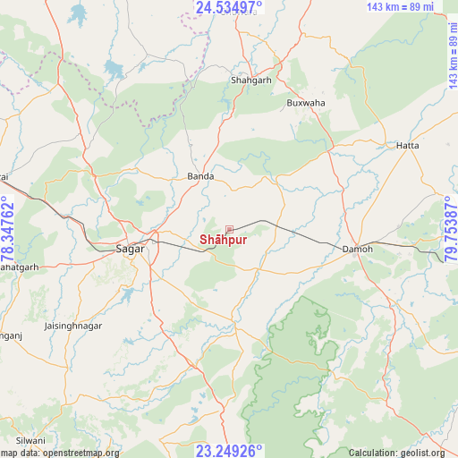
Shāhpur GPS coordinates[2]
23° 53' 37.356" North, 79° 3' 2.664" East
| Map corner | latitude | longitude |
|---|---|---|
| Upper-left | 24.53497°, | 78.34762° |
| Center: | 23.89371°, | 79.05074° |
| Lower-right: | 23.24926°, | 79.75387° |
| Map W x H: | 143×143 km | = 88.9×88.9mi |
| max Lat: | 34.9274° ⇑42.4% North |
| Shāhpur: | 23.89371° |
| min Lat: | ⇓57.6% South 8.09008° |
| min Long | Shāhpur | max Long |
| 68.82655° | 79.05074° | 96.81° |
| W 59.3%⇐ | ⇒40.7% E |
Elevation
Elevation of Shāhpur is 418 m = 1371 ft, and this is 122.4 m = 402 ft above average elevation for this country.
| Max E: |
3681 m = 12077 ft | 22.8% |
| Shāhpur | 418 m 1371 ft | |
| Avg. | 295.6 m = 970 ft | |
Min E: |
1 m = 3 ft | 77.2% |
See also: India elevation on elevation.city.
Geographical zone
Shāhpur is located in North temperate zone (between Tropic of Cancer and the Arctic Circle). Distance of this Northern Tropic circle is 50.8 km =31.6 mi to South.| Distance of | km | miles | from Shāhpur |
|---|---|---|---|
| North Pole | 7350.3 | 4567.3 | to North |
| Arctic Circle | 4744.4 | 2948 | to North |
| Tropic Cancer | 50.8 | 31.6 | to South |
| Equator | 2656.7 | 1650.8 | to South |


Nearby cities:
15 places around Shāhpur: (largest is in red/bold)
• Bakshwāho
46.4 km =28.8 mi,  31°
31°
• Banda
19.1 km =11.9 mi,  331°
331°
• Damoh
40.3 km =25 mi,  99°
99°
• Deori Khās
56.1 km =34.9 mi,  183°
183°
• Dhāna
25.2 km =15.7 mi,  229°
229°
• Garhākota
15.8 km =9.8 mi,  143°
143°
• Hatta
62 km =38.5 mi,  64°
64°
• Hindoria
52.7 km =32.7 mi,  88°
88°
• Karrāpur
19.8 km =12.3 mi,  288°
288°
• Patharia
14.6 km =9.1 mi, 87°
• Rehli
28.5 km =17.7 mi, 177°
• Rāhatgarh
67.7 km =42.1 mi,  260°
260°
• Saugor
32.3 km =20.1 mi, 259°
• Shāhgarh
47.2 km =29.3 mi,  8°
8°
• Tendūkheda
74.4 km =46.2 mi, 138°
Sources, notices
• [Note1] Compared only with cities in India existing in our database
• [Src1] Map data: © OpenStreetMap contributors (CC-BY-SA)
• [Src2] Other city data from geonames.org with taken over terms of usage.
• [Src3] Geographical zone / Annual Mean Temperature by Robert A. Rohde @ Wikipedia
