Shāhābād geodata
Shāhābād (Karnataka) is a populated place; located in India in Asia/Kolkata (GMT+5.5) time zone. With population of 52,952 people, there are 842 cities with bigger population in this country. Compared to other cities in India, 74.4% of cities are located further ↑North; 63.8% of cities are located further →East and 75.6% of cities have lower elevation than Shāhābād. Note1


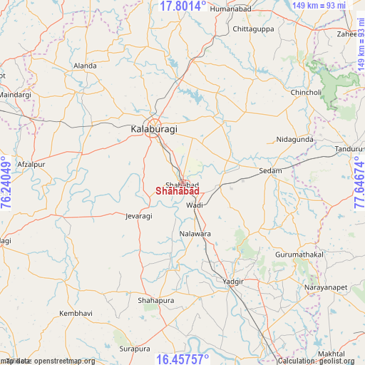
Shāhābād GPS coordinates[2]
17° 7' 50.52" North, 76° 56' 36.996" East
| Map corner | latitude | longitude |
|---|---|---|
| Upper-left | 17.8014°, | 76.24049° |
| Center: | 17.1307°, | 76.94361° |
| Lower-right: | 16.45757°, | 77.64674° |
| Map W x H: | 149.4×149.4 km | = 92.8×92.8mi |
| max Lat: | 34.9274° ⇑74.4% North |
| Shāhābād: | 17.1307° |
| min Lat: | ⇓25.6% South 8.09008° |
| min Long | Shāhābād | max Long |
| 68.82655° | 76.94361° | 96.81° |
| W 36.2%⇐ | ⇒63.8% E |
Elevation
Elevation of Shāhābād is 394 m = 1293 ft, and this is 98.4 m = 323 ft above average elevation for this country.
| Max E: |
3681 m = 12077 ft | 24.4% |
| Shāhābād | 394 m 1293 ft | |
| Avg. | 295.6 m = 970 ft | |
Min E: |
1 m = 3 ft | 75.6% |
See also: Shāhābād elevation on elevation.city.
Geographical zone
Shāhābād is located in North Torrid zone (between Equator and Tropic of Cancer). Distance of this Northern Tropic circle is 701.2 km =435.7 mi to North.| Distance of | km | miles | from Shāhābād |
|---|---|---|---|
| North Pole | 8102.3 | 5034.5 | to North |
| Arctic Circle | 5496.4 | 3415.3 | to North |
| Tropic Cancer | 701.2 | 435.7 | to North |
| Equator | 1904.8 | 1183.6 | to South |


Nearby cities:
15 places around Shāhābād: (largest is in red/bold)
• Afzalpur
62.5 km =38.8 mi,  277°
277°
• Aland
62.5 km =38.8 mi,  320°
320°
• Chincholi
62.7 km =39 mi,  53°
53°
• Chītāpur
14.8 km =9.2 mi,  93°
93°
• Dudhani
66.3 km =41.2 mi,  292°
292°
• Gulbarga
25.4 km =15.8 mi,  333°
333°
• Gurmatkāl
55.8 km =34.7 mi,  121°
121°
• Jevargi
22.3 km =13.9 mi,  234°
234°
• Kurgunta
44.5 km =27.7 mi,  81°
81°
• Seram
37.2 km =23.1 mi, 81°
• Shorāpur
70.6 km =43.9 mi,  196°
196°
• Shāhpur
49.5 km =30.8 mi,  192°
192°
• Tāndūr
68.5 km =42.6 mi, 78°
• Wādi
10.1 km =6.3 mi,  150°
150°
• Yādgīr
45.1 km =28 mi, 152°
Sources, notices
• [Note1] Compared only with cities in India existing in our database
• [Src1] Map data: © OpenStreetMap contributors (CC-BY-SA)
• [Src2] Other city data from geonames.org with taken over terms of usage.
• [Src3] Geographical zone / Annual Mean Temperature by Robert A. Rohde @ Wikipedia
