Chītāpur geodata
Chītāpur (Karnataka) is a populated place; located in India in Asia/Kolkata (GMT+5.5) time zone. With population of 30,139 people, there are 1438 cities with bigger population in this country. Compared to other cities in India, 74.5% of cities are located further ↑North; 62.2% of cities are located further →East and 76.8% of cities have lower elevation than Chītāpur. Note1


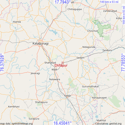
Chītāpur GPS coordinates[2]
17° 7' 24.852" North, 77° 4' 56.64" East
| Map corner | latitude | longitude |
|---|---|---|
| Upper-left | 17.7943°, | 76.37928° |
| Center: | 17.12357°, | 77.0824° |
| Lower-right: | 16.45041°, | 77.78553° |
| Map W x H: | 149.4×149.4 km | = 92.8×92.8mi |
| max Lat: | 34.9274° ⇑74.5% North |
| Chītāpur: | 17.12357° |
| min Lat: | ⇓25.5% South 8.09008° |
| min Long | Chītāpur | max Long |
| 68.82655° | 77.0824° | 96.81° |
| W 37.8%⇐ | ⇒62.2% E |
Elevation
Elevation of Chītāpur is 411 m = 1348 ft, and this is 115.4 m = 379 ft above average elevation for this country.
| Max E: |
3681 m = 12077 ft | 23.2% |
| Chītāpur | 411 m 1348 ft | |
| Avg. | 295.6 m = 970 ft | |
Min E: |
1 m = 3 ft | 76.8% |
See also: India elevation on elevation.city.
Geographical zone
Chītāpur is located in North Torrid zone (between Equator and Tropic of Cancer). Distance of this Northern Tropic circle is 702 km =436.2 mi to North.| Distance of | km | miles | from Chītāpur |
|---|---|---|---|
| North Pole | 8103.1 | 5035 | to North |
| Arctic Circle | 5497.2 | 3415.8 | to North |
| Tropic Cancer | 702 | 436.2 | to North |
| Equator | 1904 | 1183.1 | to South |


Nearby cities:
15 places around Chītāpur: (largest is in red/bold)
• Aland
73.3 km =45.5 mi,  311°
311°
• Chincholi
52.1 km =32.4 mi,  43°
43°
• Gulbarga
35.1 km =21.8 mi, 312°
• Gurmatkāl
43.4 km =27 mi,  130°
130°
• Homnābād
72.1 km =44.8 mi,  3°
3°
• Jevargi
35.1 km =21.8 mi,  249°
249°
• Kurgunta
30.3 km =18.8 mi,  75°
75°
• Nārāyanpet
60.6 km =37.7 mi, 133°
• Seram
22.9 km =14.2 mi,  74°
74°
• Shorāpur
75.4 km =46.9 mi,  207°
207°
• Shāhpur
54 km =33.6 mi, 208°
• Shāhābād
14.8 km =9.2 mi,  273°
273°
• Tāndūr
54.3 km =33.7 mi, 75°
• Wādi
12.6 km =7.8 mi,  230°
230°
• Yādgīr
39.7 km =24.7 mi,  171°
171°
Sources, notices
• [Note1] Compared only with cities in India existing in our database
• [Src1] Map data: © OpenStreetMap contributors (CC-BY-SA)
• [Src2] Other city data from geonames.org with taken over terms of usage.
• [Src3] Geographical zone / Annual Mean Temperature by Robert A. Rohde @ Wikipedia
