Sonīpat geodata
Sonīpat (Haryana) is a populated place; located in India in Asia/Kolkata (GMT+5.5) time zone. With population of 250,521 people, there are 170 cities with bigger population in this country. Compared to other cities in India, 89.1% of cities are located further ↓South; 63% of cities are located further →East and 55.8% of cities have lower elevation than Sonīpat. Note1


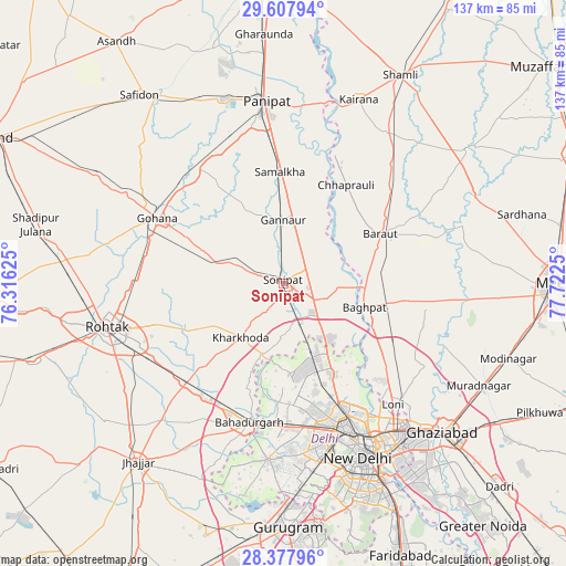
Sonīpat GPS coordinates[2]
28° 59' 41.208" North, 77° 1' 9.732" East
| Map corner | latitude | longitude |
|---|---|---|
| Upper-left | 29.60794°, | 76.31625° |
| Center: | 28.99478°, | 77.01937° |
| Lower-right: | 28.37796°, | 77.7225° |
| Map W x H: | 136.8×136.8 km | = 85×85mi |
| max Lat: | 34.9274° ⇑10.9% North |
| Sonīpat: | 28.99478° |
| min Lat: | ⇓89.1% South 8.09008° |
| min Long | Sonīpat | max Long |
| 68.82655° | 77.01937° | 96.81° |
| W 37%⇐ | ⇒63% E |
Elevation
Elevation of Sonīpat is 229 m = 751 ft, and this is 66.6 m = 219 ft below average elevation for this country.
| Max E: |
3681 m = 12077 ft | 44.2% |
| Avg. | 295.6 m = 970 ft | |
| Sonīpat | 229 m = 751 ft | |
Min E: |
1 m = 3 ft | 55.8% |
See also: Sonīpat elevation on elevation.city.
Geographical zone
Sonīpat is located in North temperate zone (between Tropic of Cancer and the Arctic Circle). Distance of this Northern Tropic circle is 618 km =384 mi to South.| Distance of | km | miles | from Sonīpat |
|---|---|---|---|
| North Pole | 6783.1 | 4214.8 | to North |
| Arctic Circle | 4177.3 | 2595.7 | to North |
| Tropic Cancer | 618 | 384 | to South |
| Equator | 3223.9 | 2003.2 | to South |


Nearby cities:
15 places around Sonīpat: (largest is in red/bold)
• Alīpur
24.5 km =15.2 mi,  153°
153°
• Bahādurgarh
34.5 km =21.4 mi,  193°
193°
• Baraut
26.5 km =16.5 mi,  63°
63°
• Bawāna
21.9 km =13.6 mi,  176°
176°
• Bāghpat
20.2 km =12.6 mi,  105°
105°
• Chhaprauli
28.3 km =17.6 mi,  32°
32°
• Gohāna
34.7 km =21.6 mi,  297°
297°
• Kharkhauda
16.7 km =10.4 mi,  219°
219°
• Khekra
29.5 km =18.3 mi,  119°
119°
• Kheri Sāmpla
33.8 km =21 mi, 224°
• Narela
17.3 km =10.7 mi,  155°
155°
• Nāngloi Jāt
35.4 km =22 mi,  172°
172°
• Pitampura
35.6 km =22.1 mi, 162°
• Rohini
28.4 km =17.6 mi, 170°
• Samālkha
26.8 km =16.7 mi,  358°
358°
Sources, notices
• [Note1] Compared only with cities in India existing in our database
• [Src1] Map data: © OpenStreetMap contributors (CC-BY-SA)
• [Src2] Other city data from geonames.org with taken over terms of usage.
• [Src3] Geographical zone / Annual Mean Temperature by Robert A. Rohde @ Wikipedia
