Shādīpur Julāna geodata
Shādīpur Julāna (Haryana) is a populated place; located in India in Asia/Kolkata (GMT+5.5) time zone. With population of 14,508 people, there are 2510 cities with bigger population in this country. Compared to other cities in India, 89.4% of cities are located further ↓South; 69.1% of cities are located further →East and 55.1% of cities have lower elevation than Shādīpur Julāna. Note1


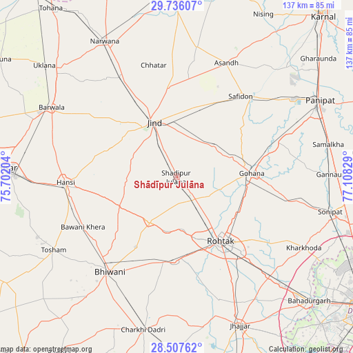
Shādīpur Julāna GPS coordinates[2]
29° 7' 25.248" North, 76° 24' 18.576" East
| Map corner | latitude | longitude |
|---|---|---|
| Upper-left | 29.73607°, | 75.70204° |
| Center: | 29.12368°, | 76.40516° |
| Lower-right: | 28.50762°, | 77.10829° |
| Map W x H: | 136.6×136.6 km | = 84.9×84.9mi |
| max Lat: | 34.9274° ⇑10.6% North |
| Shādīpur Julāna: | 29.12368° |
| min Lat: | ⇓89.4% South 8.09008° |
| min Long | Shādīpur Jul� | max Long |
| 68.82655° | 76.40516° | 96.81° |
| W 30.9%⇐ | ⇒69.1% E |
Elevation
Elevation of Shādīpur Julāna is 227 m = 745 ft, and this is 68.6 m = 225 ft below average elevation for this country.
| Max E: |
3681 m = 12077 ft | 44.9% |
| Avg. | 295.6 m = 970 ft | |
| Shādīpur Julāna | 227 m = 745 ft | |
Min E: |
1 m = 3 ft | 55.1% |
See also: India elevation on elevation.city.
Geographical zone
Shādīpur Julāna is located in North temperate zone (between Tropic of Cancer and the Arctic Circle). Distance of this Northern Tropic circle is 632.3 km =392.9 mi to South.| Distance of | km | miles | from Shādīpur Julāna |
|---|---|---|---|
| North Pole | 6768.8 | 4205.9 | to North |
| Arctic Circle | 4162.9 | 2586.7 | to North |
| Tropic Cancer | 632.3 | 392.9 | to South |
| Equator | 3238.2 | 2012.1 | to South |


Nearby cities:
15 places around Shādīpur Julāna: (largest is in red/bold)
• Bara Uchāna
44.1 km =27.4 mi,  330°
330°
• Barwāla
55.3 km =34.4 mi,  299°
299°
• Beri Khās
49.8 km =30.9 mi,  160°
160°
• Bhiwāni
44.9 km =27.9 mi,  215°
215°
• Gohāna
28.9 km =18 mi,  86°
86°
• Hānsi
43.1 km =26.8 mi,  266°
266°
• Jīnd
23.1 km =14.4 mi,  337°
337°
• Kalānaur
32.9 km =20.4 mi,  181°
181°
• Kheri Sāmpla
52.7 km =32.7 mi,  136°
136°
• Maham
20.3 km =12.6 mi,  211°
211°
• Nārnaund
27.7 km =17.2 mi,  292°
292°
• Rohtak
31.1 km =19.3 mi, 144°
• Safidon
40.6 km =25.2 mi,  39°
39°
• Toshām
55.3 km =34.4 mi,  239°
239°
• Āsandh
48.3 km =30 mi,  23°
23°
Sources, notices
• [Note1] Compared only with cities in India existing in our database
• [Src1] Map data: © OpenStreetMap contributors (CC-BY-SA)
• [Src2] Other city data from geonames.org with taken over terms of usage.
• [Src3] Geographical zone / Annual Mean Temperature by Robert A. Rohde @ Wikipedia
