Kyathampalle geodata
Kyathampalle (Telangana) is a populated place; located in India in Asia/Kolkata (GMT+5.5) time zone. With population of 42,275 people, there are 1045 cities with bigger population in this country. Compared to other cities in India, 66.4% of cities are located further ↑North; 54.5% of cities are located further ←West and 61.5% of cities have lower elevation than Kyathampalle. Note1


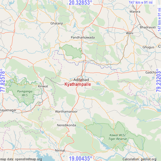
Kyathampalle GPS coordinates[2]
19° 40' 4.116" North, 78° 31' 44.04" East
| Map corner | latitude | longitude |
|---|---|---|
| Upper-left | 20.32853°, | 77.82578° |
| Center: | 19.66781°, | 78.5289° |
| Lower-right: | 19.00435°, | 79.23203° |
| Map W x H: | 147.2×147.2 km | = 91.5×91.5mi |
| max Lat: | 34.9274° ⇑66.4% North |
| Kyathampalle: | 19.66781° |
| min Lat: | ⇓33.6% South 8.09008° |
| min Long | Kyathampalle | max Long |
| 68.82655° | 78.5289° | 96.81° |
| W 54.5%⇐ | ⇒45.5% E |
Elevation
Elevation of Kyathampalle is 262 m = 860 ft, and this is 33.6 m = 110 ft below average elevation for this country.
| Max E: |
3681 m = 12077 ft | 38.5% |
| Avg. | 295.6 m = 970 ft | |
| Kyathampalle | 262 m = 860 ft | |
Min E: |
1 m = 3 ft | 61.5% |
See also: Kyathampalle elevation on elevation.city.
Geographical zone
Kyathampalle is located in North Torrid zone (between Equator and Tropic of Cancer). Distance of this Northern Tropic circle is 419.1 km =260.4 mi to North.| Distance of | km | miles | from Kyathampalle |
|---|---|---|---|
| North Pole | 7820.2 | 4859.2 | to North |
| Arctic Circle | 5214.3 | 3240 | to North |
| Tropic Cancer | 419.1 | 260.4 | to North |
| Equator | 2186.9 | 1358.9 | to South |


Nearby cities:
15 places around Kyathampalle: (largest is in red/bold)
• Asifābād
86.3 km =53.6 mi,  113°
113°
• Ballālpur
87.8 km =54.6 mi,  76°
76°
• Bhaisa
85.6 km =53.2 mi,  223°
223°
• Chānda
86.1 km =53.5 mi,  68°
68°
• Chāndur
67.7 km =42.1 mi, 83°
• Dasnapur
2.3 km =1.4 mi,  228°
228°
• Ghugus
68 km =42.3 mi,  63°
63°
• Ghātanji
57.3 km =35.6 mi,  336°
336°
• Kinwat
34.9 km =21.7 mi,  262°
262°
• Nirmal
66.4 km =41.3 mi,  196°
196°
• Rājur
62.3 km =38.7 mi,  37°
37°
• Rājūra
88.3 km =54.9 mi, 81°
• Wani
61.8 km =38.4 mi,  45°
45°
• Warora
79.7 km =49.5 mi, 38°
• Ādilābād
0.9 km =0.6 mi, 57°
Sources, notices
• [Note1] Compared only with cities in India existing in our database
• [Src1] Map data: © OpenStreetMap contributors (CC-BY-SA)
• [Src2] Other city data from geonames.org with taken over terms of usage.
• [Src3] Geographical zone / Annual Mean Temperature by Robert A. Rohde @ Wikipedia
