Kinwat geodata
Kinwat (Maharashtra) is a populated place; located in India in Asia/Kolkata (GMT+5.5) time zone. With population of 25,956 people, there are 1639 cities with bigger population in this country. Compared to other cities in India, 66.6% of cities are located further ↑North; 51.1% of cities are located further ←West and 69% of cities have lower elevation than Kinwat. Note1


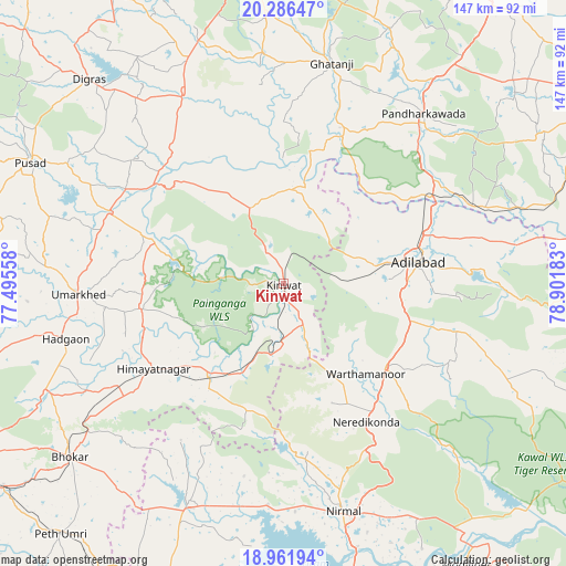
Kinwat GPS coordinates[2]
19° 37' 32.052" North, 78° 11' 55.32" East
| Map corner | latitude | longitude |
|---|---|---|
| Upper-left | 20.28647°, | 77.49558° |
| Center: | 19.62557°, | 78.1987° |
| Lower-right: | 18.96194°, | 78.90183° |
| Map W x H: | 147.3×147.3 km | = 91.5×91.5mi |
| max Lat: | 34.9274° ⇑66.6% North |
| Kinwat: | 19.62557° |
| min Lat: | ⇓33.4% South 8.09008° |
| min Long | Kinwat | max Long |
| 68.82655° | 78.1987° | 96.81° |
| W 51.1%⇐ | ⇒48.9% E |
Elevation
Elevation of Kinwat is 317 m = 1040 ft, and this is 21.4 m = 70 ft above average elevation for this country.
| Max E: |
3681 m = 12077 ft | 31% |
| Kinwat | 317 m 1040 ft | |
| Avg. | 295.6 m = 970 ft | |
Min E: |
1 m = 3 ft | 69% |
See also: India elevation on elevation.city.
Geographical zone
Kinwat is located in North Torrid zone (between Equator and Tropic of Cancer). Distance of this Northern Tropic circle is 423.8 km =263.3 mi to North.| Distance of | km | miles | from Kinwat |
|---|---|---|---|
| North Pole | 7824.9 | 4862.2 | to North |
| Arctic Circle | 5219 | 3242.9 | to North |
| Tropic Cancer | 423.8 | 263.3 | to North |
| Equator | 2182.2 | 1356 | to South |


Nearby cities:
15 places around Kinwat: (largest is in red/bold)
• Bhaisa
62.1 km =38.6 mi,  203°
203°
• Dasnapur
33 km =20.5 mi,  84°
84°
• Dharmābād
89.5 km =55.6 mi, 204°
• Digras
73.1 km =45.4 mi,  316°
316°
• Dārwha
88.2 km =54.8 mi,  329°
329°
• Ghātanji
58.6 km =36.4 mi,  11°
11°
• Hadgāon
58.4 km =36.3 mi,  255°
255°
• Kyathampalle
34.9 km =21.7 mi, 82°
• Mudkhed
89.7 km =55.7 mi,  234°
234°
• Nirmal
60.7 km =37.7 mi,  165°
165°
• Pusad
72.3 km =44.9 mi,  296°
296°
• Rājur
90.5 km =56.2 mi,  53°
53°
• Umarkhed
53.5 km =33.2 mi,  267°
267°
• Yavatmāl
85.6 km =53.2 mi,  355°
355°
• Ādilābād
35.7 km =22.2 mi, 81°
Sources, notices
• [Note1] Compared only with cities in India existing in our database
• [Src1] Map data: © OpenStreetMap contributors (CC-BY-SA)
• [Src2] Other city data from geonames.org with taken over terms of usage.
• [Src3] Geographical zone / Annual Mean Temperature by Robert A. Rohde @ Wikipedia
