Dankaur geodata
Dankaur (Uttar Pradesh) is a populated place; located in India in Asia/Kolkata (GMT+5.5) time zone. With population of 13,020 people, there are 2655 cities with bigger population in this country. Compared to other cities in India, 86.2% of cities are located further ↓South; 56.5% of cities are located further →East and 50.9% of cities have lower elevation than Dankaur. Note1


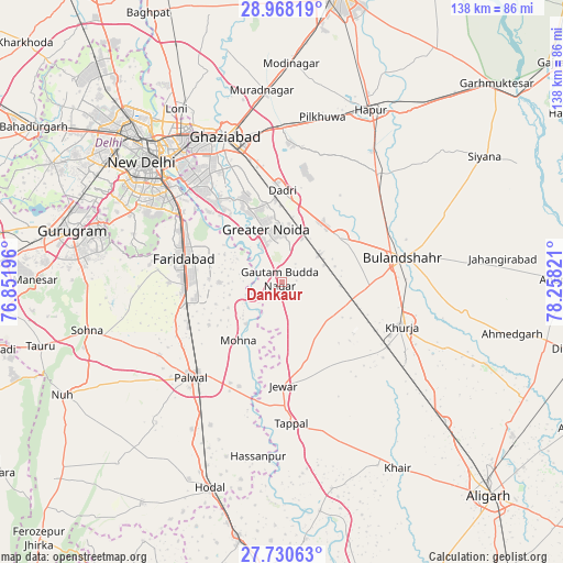
Dankaur GPS coordinates[2]
28° 21' 4.356" North, 77° 33' 18.288" East
| Map corner | latitude | longitude |
|---|---|---|
| Upper-left | 28.96819°, | 76.85196° |
| Center: | 28.35121°, | 77.55508° |
| Lower-right: | 27.73063°, | 78.25821° |
| Map W x H: | 137.6×137.6 km | = 85.5×85.5mi |
| max Lat: | 34.9274° ⇑13.8% North |
| Dankaur: | 28.35121° |
| min Lat: | ⇓86.2% South 8.09008° |
| min Long | Dankaur | max Long |
| 68.82655° | 77.55508° | 96.81° |
| W 43.5%⇐ | ⇒56.5% E |
Elevation
Elevation of Dankaur is 207 m = 679 ft, and this is 88.6 m = 291 ft below average elevation for this country.
| Max E: |
3681 m = 12077 ft | 49.1% |
| Avg. | 295.6 m = 970 ft | |
| Dankaur | 207 m = 679 ft | |
Min E: |
1 m = 3 ft | 50.9% |
See also: India elevation on elevation.city.
Geographical zone
Dankaur is located in North temperate zone (between Tropic of Cancer and the Arctic Circle). Distance of this Northern Tropic circle is 546.4 km =339.5 mi to South.| Distance of | km | miles | from Dankaur |
|---|---|---|---|
| North Pole | 6854.7 | 4259.3 | to North |
| Arctic Circle | 4248.8 | 2640.1 | to North |
| Tropic Cancer | 546.4 | 339.5 | to South |
| Equator | 3152.4 | 1958.8 | to South |


Nearby cities:
15 places around Dankaur: (largest is in red/bold)
• Bulandshahr
30.2 km =18.8 mi,  78°
78°
• Bīlāspur
8.1 km =5 mi,  56°
56°
• Deoli
35.9 km =22.3 mi,  297°
297°
• Dādri
22.4 km =13.9 mi,  359°
359°
• Faridabad
24.6 km =15.3 mi,  285°
285°
• Greater Noida
16.2 km =10.1 mi,  353°
353°
• Gulāothi
35.3 km =21.9 mi,  41°
41°
• Jahāngīrpur
24.1 km =15 mi,  142°
142°
• Jewar
25.5 km =15.8 mi,  179°
179°
• Khurja
31.3 km =19.4 mi,  110°
110°
• Noida
33.6 km =20.9 mi,  319°
319°
• Palwal
32.1 km =19.9 mi,  224°
224°
• Rabūpura
12 km =7.5 mi,  157°
157°
• Sector
33.1 km =20.6 mi, 317°
• Sikandarābād
18.1 km =11.2 mi,  51°
51°
Sources, notices
• [Note1] Compared only with cities in India existing in our database
• [Src1] Map data: © OpenStreetMap contributors (CC-BY-SA)
• [Src2] Other city data from geonames.org with taken over terms of usage.
• [Src3] Geographical zone / Annual Mean Temperature by Robert A. Rohde @ Wikipedia
