Dādri geodata
Dādri (Uttar Pradesh) is a populated place; located in India in Asia/Kolkata (GMT+5.5) time zone. With population of 70,609 people, there are 618 cities with bigger population in this country. Compared to other cities in India, 87% of cities are located further ↓South; 56.6% of cities are located further →East and 52.3% of cities have lower elevation than Dādri. Note1


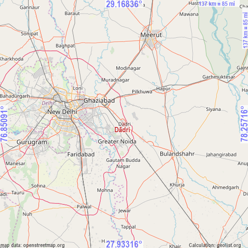
Dādri GPS coordinates[2]
28° 33' 9.252" North, 77° 33' 14.508" East
| Map corner | latitude | longitude |
|---|---|---|
| Upper-left | 29.16836°, | 76.85091° |
| Center: | 28.55257°, | 77.55403° |
| Lower-right: | 27.93316°, | 78.25716° |
| Map W x H: | 137.3×137.3 km | = 85.3×85.3mi |
| max Lat: | 34.9274° ⇑13% North |
| Dādri: | 28.55257° |
| min Lat: | ⇓87% South 8.09008° |
| min Long | Dādri | max Long |
| 68.82655° | 77.55403° | 96.81° |
| W 43.4%⇐ | ⇒56.6% E |
Elevation
Elevation of Dādri is 214 m = 702 ft, and this is 81.6 m = 268 ft below average elevation for this country.
| Max E: |
3681 m = 12077 ft | 47.7% |
| Avg. | 295.6 m = 970 ft | |
| Dādri | 214 m = 702 ft | |
Min E: |
1 m = 3 ft | 52.3% |
See also: Dādri elevation on elevation.city.
Geographical zone
Dādri is located in North temperate zone (between Tropic of Cancer and the Arctic Circle). Distance of this Northern Tropic circle is 568.8 km =353.4 mi to South.| Distance of | km | miles | from Dādri |
|---|---|---|---|
| North Pole | 6832.3 | 4245.4 | to North |
| Arctic Circle | 4226.4 | 2626.2 | to North |
| Tropic Cancer | 568.8 | 353.4 | to South |
| Equator | 3174.7 | 1972.7 | to South |


Nearby cities:
15 places around Dādri: (largest is in red/bold)
• Bīlāspur
19.2 km =11.9 mi,  159°
159°
• Dankaur
22.4 km =13.9 mi,  179°
179°
• Defence Colony
31.4 km =19.5 mi,  273°
273°
• Dāsna
14.2 km =8.8 mi,  347°
347°
• Faridabad
28.3 km =17.6 mi,  236°
236°
• Farīdnagar
25.2 km =15.7 mi,  16°
16°
• Ghāziābād
16.8 km =10.4 mi,  318°
318°
• Greater Noida
6.5 km =4 mi,  195°
195°
• Gulāothi
23.7 km =14.7 mi,  80°
80°
• Hāpur
29.6 km =18.4 mi,  48°
48°
• Murādnagar
25.9 km =16.1 mi, 347°
• Noida
22.1 km =13.7 mi,  277°
277°
• Pilkhua
20.4 km =12.7 mi,  29°
29°
• Sector
22.4 km =13.9 mi, 275°
• Sikandarābād
18.1 km =11.2 mi,  128°
128°
Sources, notices
• [Note1] Compared only with cities in India existing in our database
• [Src1] Map data: © OpenStreetMap contributors (CC-BY-SA)
• [Src2] Other city data from geonames.org with taken over terms of usage.
• [Src3] Geographical zone / Annual Mean Temperature by Robert A. Rohde @ Wikipedia
