Greater Noida geodata
Greater Noida (Uttar Pradesh) is a populated place; located in India in Asia/Kolkata (GMT+5.5) time zone. With population of 293,908 people, there are 149 cities with bigger population in this country. Compared to other cities in India, 86.8% of cities are located further ↓South; 56.9% of cities are located further →East and 51.7% of cities have lower elevation than Greater Noida. Note1


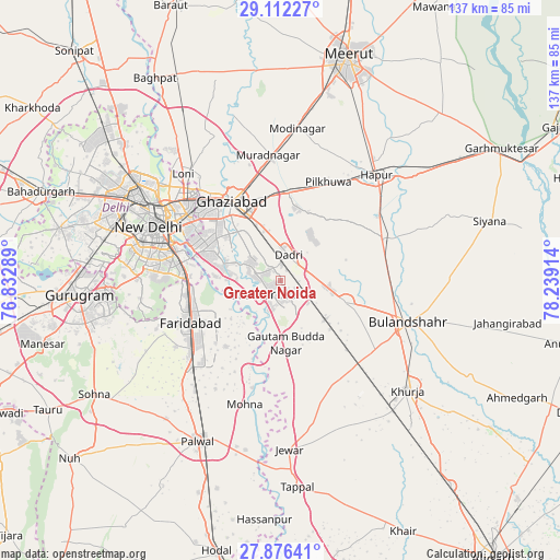
Greater Noida GPS coordinates[2]
28° 29' 46.14" North, 77° 32' 9.636" East
| Map corner | latitude | longitude |
|---|---|---|
| Upper-left | 29.11227°, | 76.83289° |
| Center: | 28.49615°, | 77.53601° |
| Lower-right: | 27.87641°, | 78.23914° |
| Map W x H: | 137.4×137.4 km | = 85.4×85.4mi |
| max Lat: | 34.9274° ⇑13.2% North |
| Greater Noida: | 28.49615° |
| min Lat: | ⇓86.8% South 8.09008° |
| min Long | Greater Noida | max Long |
| 68.82655° | 77.53601° | 96.81° |
| W 43.1%⇐ | ⇒56.9% E |
Elevation
Elevation of Greater Noida is 212 m = 696 ft, and this is 83.6 m = 274 ft below average elevation for this country.
| Max E: |
3681 m = 12077 ft | 48.3% |
| Avg. | 295.6 m = 970 ft | |
| Greater Noida | 212 m = 696 ft | |
Min E: |
1 m = 3 ft | 51.7% |
See also: Greater Noida elevation on elevation.city.
Geographical zone
Greater Noida is located in North temperate zone (between Tropic of Cancer and the Arctic Circle). Distance of this Northern Tropic circle is 562.6 km =349.6 mi to South.| Distance of | km | miles | from Greater Noida |
|---|---|---|---|
| North Pole | 6838.6 | 4249.3 | to North |
| Arctic Circle | 4232.7 | 2630.1 | to North |
| Tropic Cancer | 562.6 | 349.6 | to South |
| Equator | 3168.5 | 1968.8 | to South |


Nearby cities:
15 places around Greater Noida: (largest is in red/bold)
• Bīlāspur
14.5 km =9 mi,  143°
143°
• Dankaur
16.2 km =10.1 mi,  173°
173°
• Defence Colony
30.8 km =19.1 mi,  285°
285°
• Deoli
29.8 km =18.5 mi,  271°
271°
• Dādri
6.5 km =4 mi,  15°
15°
• Dāsna
20.2 km =12.6 mi,  356°
356°
• Faridabad
23.7 km =14.7 mi,  246°
246°
• Farīdnagar
31.7 km =19.7 mi, 16°
• Ghāziābād
21.1 km =13.1 mi,  333°
333°
• Gulāothi
27.2 km =16.9 mi,  67°
67°
• Noida
22.2 km =13.8 mi, 294°
• Pilkhua
26.8 km =16.7 mi,  25°
25°
• Rabūpura
28 km =17.4 mi, 166°
• Sector
22.1 km =13.7 mi, 292°
• Sikandarābād
16.8 km =10.4 mi,  106°
106°
Sources, notices
• [Note1] Compared only with cities in India existing in our database
• [Src1] Map data: © OpenStreetMap contributors (CC-BY-SA)
• [Src2] Other city data from geonames.org with taken over terms of usage.
• [Src3] Geographical zone / Annual Mean Temperature by Robert A. Rohde @ Wikipedia
