Bīlāspur geodata
Bīlāspur (Uttar Pradesh) is a populated place; located in India in Asia/Kolkata (GMT+5.5) time zone. With population of 8,036 people, there are 3123 cities with bigger population in this country. Compared to other cities in India, 86.3% of cities are located further ↓South; 55.7% of cities are located further →East and 50.9% of cities have lower elevation than Bīlāspur. Note1


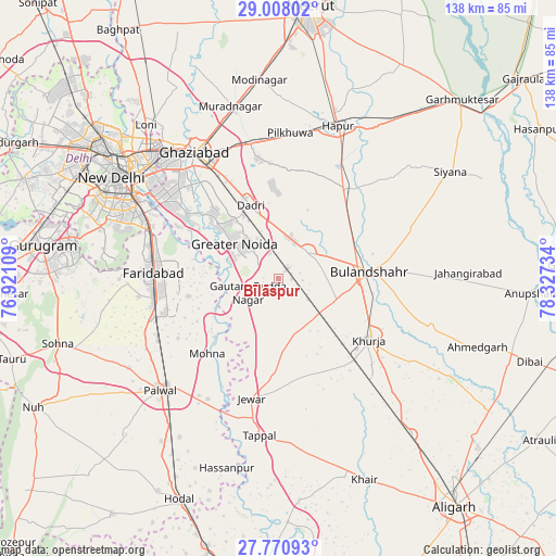
Bīlāspur GPS coordinates[2]
28° 23' 28.608" North, 77° 37' 27.156" East
| Map corner | latitude | longitude |
|---|---|---|
| Upper-left | 29.00802°, | 76.92109° |
| Center: | 28.39128°, | 77.62421° |
| Lower-right: | 27.77093°, | 78.32734° |
| Map W x H: | 137.6×137.6 km | = 85.5×85.5mi |
| max Lat: | 34.9274° ⇑13.7% North |
| Bīlāspur: | 28.39128° |
| min Lat: | ⇓86.3% South 8.09008° |
| min Long | Bīlāspur | max Long |
| 68.82655° | 77.62421° | 96.81° |
| W 44.3%⇐ | ⇒55.7% E |
Elevation
Elevation of Bīlāspur is 207 m = 679 ft, and this is 88.6 m = 291 ft below average elevation for this country.
| Max E: |
3681 m = 12077 ft | 49.1% |
| Avg. | 295.6 m = 970 ft | |
| Bīlāspur | 207 m = 679 ft | |
Min E: |
1 m = 3 ft | 50.9% |
See also: India elevation on elevation.city.
Geographical zone
Bīlāspur is located in North temperate zone (between Tropic of Cancer and the Arctic Circle). Distance of this Northern Tropic circle is 550.9 km =342.3 mi to South.| Distance of | km | miles | from Bīlāspur |
|---|---|---|---|
| North Pole | 6850.2 | 4256.5 | to North |
| Arctic Circle | 4244.4 | 2637.3 | to North |
| Tropic Cancer | 550.9 | 342.3 | to South |
| Equator | 3156.8 | 1961.5 | to South |


Nearby cities:
15 places around Bīlāspur: (largest is in red/bold)
• Bulandshahr
22.9 km =14.2 mi,  86°
86°
• Dankaur
8.1 km =5 mi,  236°
236°
• Dādri
19.2 km =11.9 mi,  339°
339°
• Dāsna
33.3 km =20.7 mi, 342°
• Faridabad
30.5 km =19 mi,  274°
274°
• Ghāziābād
35.4 km =22 mi,  329°
329°
• Greater Noida
14.5 km =9 mi,  323°
323°
• Gulāothi
27.5 km =17.1 mi,  36°
36°
• Jahāngīrpur
24.9 km =15.5 mi,  161°
161°
• Jewar
30.6 km =19 mi,  192°
192°
• Khurja
27.3 km =17 mi,  124°
124°
• Noida
35.6 km =22.1 mi,  306°
306°
• Rabūpura
15.7 km =9.8 mi, 187°
• Sector
35.3 km =21.9 mi,  304°
304°
• Sikandarābād
10 km =6.2 mi,  47°
47°
Sources, notices
• [Note1] Compared only with cities in India existing in our database
• [Src1] Map data: © OpenStreetMap contributors (CC-BY-SA)
• [Src2] Other city data from geonames.org with taken over terms of usage.
• [Src3] Geographical zone / Annual Mean Temperature by Robert A. Rohde @ Wikipedia
