Balrampur geodata
Balrampur (Chhattisgarh) is a seat of a second-order administrative division; located in India in Asia/Kolkata (GMT+5.5) time zone. In our database, there are 3475 cities with bigger population. Compared to other cities in India, 55.4% of cities are located further ↓South; 81.1% of cities are located further ←West and 84% of cities have lower elevation than Balrampur. Note1


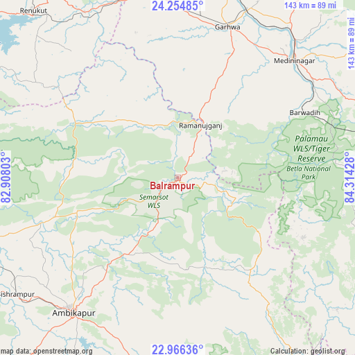
Balrampur GPS coordinates[2]
23° 36' 43.884" North, 83° 36' 40.14" East
| Map corner | latitude | longitude |
|---|---|---|
| Upper-left | 24.25485°, | 82.90803° |
| Center: | 23.61219°, | 83.61115° |
| Lower-right: | 22.96636°, | 84.31428° |
| Map W x H: | 143.3×143.3 km | = 89×89mi |
| max Lat: | 34.9274° ⇑44.6% North |
| Balrampur: | 23.61219° |
| min Lat: | ⇓55.4% South 8.09008° |
| min Long | Balrampur | max Long |
| 68.82655° | 83.61115° | 96.81° |
| W 81.1%⇐ | ⇒18.9% E |
Elevation
Elevation of Balrampur is 532 m = 1745 ft, and this is 236.4 m = 776 ft above average elevation for this country.
| Max E: |
3681 m = 12077 ft | 16% |
| Balrampur | 532 m 1745 ft | |
| Avg. | 295.6 m = 970 ft | |
Min E: |
1 m = 3 ft | 84% |
See also: India elevation on elevation.city.
Geographical zone
Balrampur is located in North temperate zone (between Tropic of Cancer and the Arctic Circle). Distance of this Northern Tropic circle is 19.5 km =12.1 mi to South.| Distance of | km | miles | from Balrampur |
|---|---|---|---|
| North Pole | 7381.6 | 4586.7 | to North |
| Arctic Circle | 4775.7 | 2967.5 | to North |
| Tropic Cancer | 19.5 | 12.1 | to South |
| Equator | 2625.4 | 1631.3 | to South |


Nearby cities:
15 places around Balrampur: (largest is in red/bold)
• Ambikāpur
69.3 km =43.1 mi,  217°
217°
• Barwādih
57.2 km =35.5 mi,  62°
62°
• Daltonganj
66.3 km =41.2 mi,  44°
44°
• Dūdhi
76.7 km =47.7 mi,  330°
330°
• Garhwa
64.1 km =39.8 mi,  18°
18°
• Husainābād
109.3 km =67.9 mi, 21°
• Jashpurnagar
96.9 km =60.2 mi,  146°
146°
• Kota
104.8 km =65.1 mi, 332°
• Lohārdagā
110.8 km =68.8 mi,  100°
100°
• Lātehār
91.7 km =57 mi,  80°
80°
• Neturhāt
68.7 km =42.7 mi, 102°
• Obra
109.8 km =68.2 mi,  324°
324°
• Renukūt
89.1 km =55.4 mi, 318°
• Rāmānuj Ganj
23.4 km =14.5 mi, 22°
• Surajpur
87.8 km =54.6 mi,  239°
239°
Sources, notices
• [Note1] Compared only with cities in India existing in our database
• [Src1] Map data: © OpenStreetMap contributors (CC-BY-SA)
• [Src2] Other city data from geonames.org with taken over terms of usage.
• [Src3] Geographical zone / Annual Mean Temperature by Robert A. Rohde @ Wikipedia
